Updated: 30 July 2019 |
|
Length: About 1¾ miles |
|
Duration: Around 2 hours |
|
Appendix: Click to view |
|
PDF: Click to download |
A walk from Clerkenwell to Islington
HIGHLIGHTS OF THE WALK
Exmouth Market, Finsbury Town Hall, New River Head, Sadler’s Wells, Myddleton Square and St Mark’s Church, Pentonville Road, The Angel, Islington Tunnel, Camden Passage, Business Design Centre.
Please note – this walk can also be done as an extension to the Farringdon to Clerkenwell walk.
Start: Exmouth Market |
|
Finish: Angel Islington |
WHERE TO START THE WALK
This walk begins at Exmouth Market, which is at the junction of Farringdon Road and Rosebery Road.
For some background information on the Clerkenwell area please see the beginning of the walk from Farringdon to Clerkenwell.

GETTING HERE
Coming by bus
There are a number of bus routes that serve the area, including:
Number 19 – from Battersea and other points south of the river, Hyde Park Corner, Piccadilly Circus, Cambridge Circus.
Number 38 – from Victoria, Piccadilly Circus, Cambridge Circus, Gray’s Inn Road.
Number 63 – from Blackfriars, Newgate Street (Old Bailey/City Thameslink station)
Farringdon Station.
Number 341 – Waterloo, Aldwych (Somerset House), Holborn.
If you intend to travel here by bus, you may wish to use TfL’s journey planner before you set off: tfl.gov.uk/plan-a-journey/.
By tube
The closest tube station is Farringdon (on the Circle, Hammersmith & City and Metropolitan lines). From there it’s a 10–15 minute walk (just under half a mile).
Assuming you’re exiting via the old part of the station, turn to the left. After twenty yards turn left up Turnmill Street, which runs up alongside the station. (It is so named because of the watermills that used to operate here. These were powered by the River Fleet, which now runs under the adjacent Farringdon Road.)
Continue on up Farringdon Lane, passing the Betsey Trotwood pub on your left – it’s built directly over the top of the railway lines. Carry on walking straight ahead up Farringdon Road until you reach the top of the gradient, and Exmouth Market is just before the traffic lights at the junction with Rosebery Avenue. Then turn right along Exmouth Market and pick up the walk as below.


STARTING THE WALK
The walk starts in Exmouth Market, a lively, semi-pedestrianised thoroughfare that at one time had a popular street market – but after it closed the street became rather run down. More recently a number of bars, restaurants and ‘gift’ shops have opened and as a result it’s become a busy and lively place, particularly in the evening. Many of the bars and restaurants have outside seating, making it a particularly attractive place to visit in nice weather. A food market has also been introduced on weekdays, which has become popular with both residents and those working locally at lunchtimes.
Walking from the Farringdon Road end of Exmouth Market, you pass the Church of Our Most Holy Redeemer. I like its Italianate look and it’s one of a select few basilica-style churches in London.
If it’s open, take a look inside. You could easily believe this is a Catholic church, but it’s actually Church of England, although known as ‘Anglo-Catholic’. This means that it is within the ‘Catholic tradition’ of the Church of England and receives ‘alternate episcopal oversight’ from the Bishop of Fulham. (Episcopal oversight is commonly known as a ‘flying bishop” – a Church of England bishop assigned to minister to those clergy and parishes that ‘are unable to receive the ministry of women bishops or priests’.)
Almost opposite the church is a pub called the Exmouth Arms – the street was originally called Baynes Row, but in 1939 it was renamed after the pub.
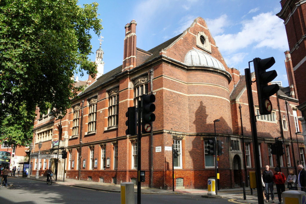
At the end of Exmouth Market, we head more or less straight across the junction – crossing over Tysoe and Rosoman Streets and turning left up Garnault Place. On your left is the large and architecturally unusual (but now sadly a little tired looking) building that was once Finsbury Town Hall. It ceased to be this when the Borough of Finsbury was absorbed by the neighbouring Borough of Islington in the 1960s. In the entrance lobby there’s a brass plaque that lists all the mayors of Finsbury since 1900.

At the top of Garnault Place use the crossing to walk across Rosebery Avenue. We’re going to walk to the right – but as you do you can’t fail to notice the large and attractive building that’s slightly offset, partly facing back down Rosebery Avenue.
The sign carved into the stone above the grand wooden front doors explains that this was once the ‘Head Office of the Metropolitan Water Board’. It has kept its original name of the ‘New River Head’, though now converted into some very expensive apartments. On several occasions I have tried to look inside, but the door was always locked, so on the last occasion I stood outside and waited until a resident went in, then slipped in behind him. Fortunately, the porter was really friendly and helpful and let me take a brief look and I have to say the enormous and quite magnificent reception area has been beautifully preserved. On the first floor is the ‘architecturally renowned’ Oak Room, which is open to the public on special occasions.
As you continue along Rosebery Avenue, look back to the New River Head building and you can see just how large it is. It’s set in the extensive grounds where the water that was brought in from Herefordshire via the New River and conduits was stored and treated. There was even a windmill here to drive the pumps – the windmill has been demolished but the base is still there.
You pass the private gardens belonging to the apartments, complete with a small fountain and at the far end is the ‘Laboratory Building’. It was built in 1938 for undertaking research and quality testing of the water supply and as with New River Head it has now been converted into apartments.
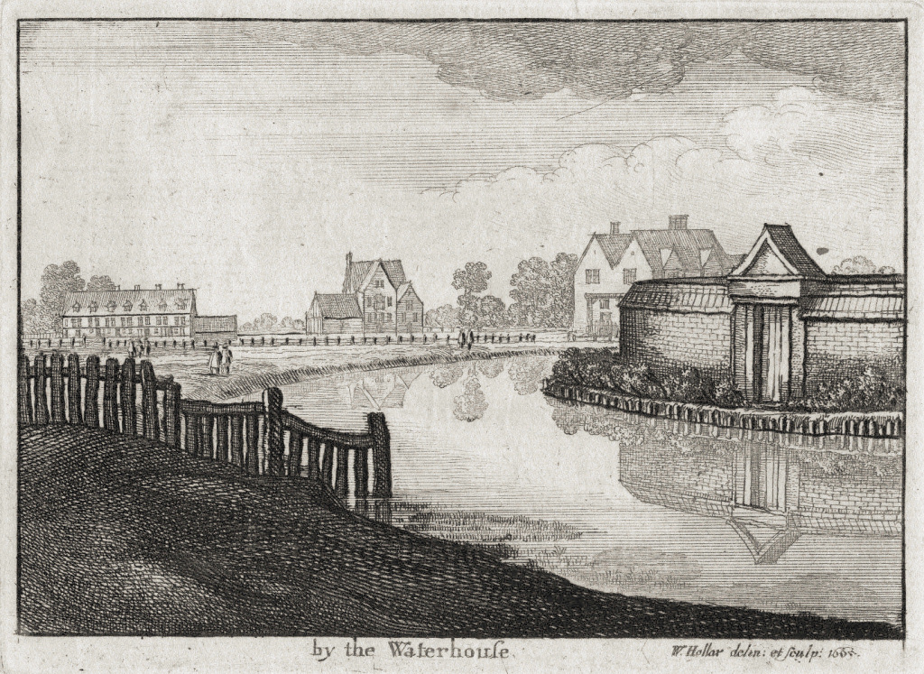

The small park on the opposite side of Rosebery Avenue was once part of the extensive Islington Spa gardens, which were in competition with the Sadler’s Wells Gardens opposite.
Islington Spa, also called the New Wells and later the ‘New Tunbridge Wells’, on account of the medicinal quality of its waters apparently being as good as those of Royal Tunbridge Wells, opened in 1737. It was claimed the water could cure all manner of ailments including ‘Hysterics, Vapours, Dropsies, Swellings of the Legs, Rheumatics, Scurvy, Jaundice, Want of Digestion, Gravel, Gout, Strangury, and more.’ At the height of its popularity up to 1,600 people a day visited the gardens, where entertainments included a miniature zoo, a Merlin’s Cave and coffee houses. The area began to be built over from 1810 onwards, though the spring waters flowed until the 1860s.
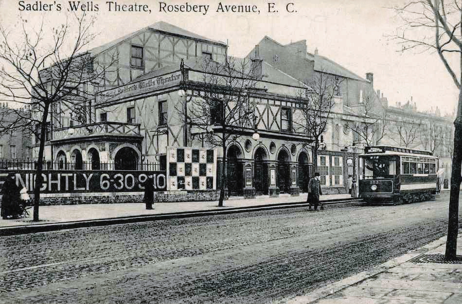
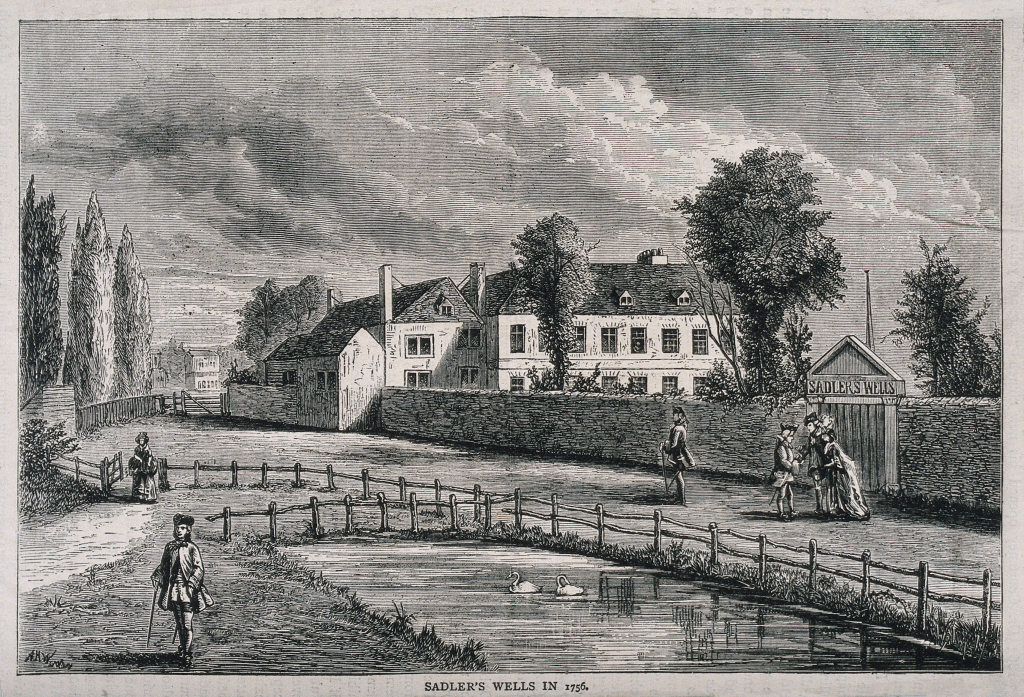
Turn left up alongside the Laboratory Building into Arlington Way – and on the other corner you can’t miss the Sadler’s Wells Theatre.
Continue up Arlington Way, passing the Shakespeare’s Head pub and a rather rundown apartment building on the left, there’s a nice row of terraced houses on the opposite side, many of which were once shops with living accommodation above.
Time to stop for a snack?
The Fox Garden Court Café at Sadler’s Wells is open to members of the cast and the public. But if this is a little early in the walk, you could hold off until you get to Camden Passage, where there’s a wide choice of quirky eateries and pleasing neighbouring pubs.
Time to stop for a snack?
The Fox Garden Court Café at Sadler’s Wells is open to members of the cast and the public. But if this is a little early in the walk, you could hold off until you get to Camden Passage, where there’s a wide choice of quirky eateries and pleasing neighbouring pubs.

At the top turn left into the very wide Chadwell Street, which has some interesting and surprisingly large terraced houses on both sides. Next to the Thomas Treacy Funeral Directors on the corner on the left is an elegant Grade II listed building that was built in 1824 built for Calvinistic Methodists and called the Providence Chapel. It’s now the Angel Baptist Church.
Chadwell Street runs into the enormous Myddelton Square, with the equally large St Mark’s Church and churchyard in the centre.
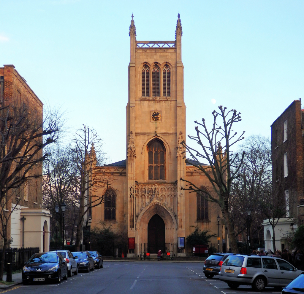
Walk through the gate that’s directly ahead of you into the churchyard. Unfortunately you can’t walk across and out the other side, so having had a look around leave by the gate on the left-hand side and walk around the square to the front of the church.
Leave the square along Inglebert Street that is directly opposite the front entrance of the church and at the end turn right, then walk up the equally wide Amwell Street, taking the next right into Claremont Square.
The large grass mound on your left is the Claremont Square Reservoir, which was built in 1709 by the New River Company to store water being brought in from Herefordshire via the New River. It was originally called the Upper Pond, but in the 1850s the Metropolis Water Act was passed, which prohibited open areas of standing water in London and so it was covered and grassed over and is still in use today.
At the end of the road turn to the left and continue up Claremont Square – but straight ahead of you is Claremont Close. Although we don’t actually walk down it, I will just mention that Claremont Close was originally the site of livery stables and pens for cattle en route to Smithfield Market. The eight blocks of apartments that now surround the close were built in the mid-1930s – much later than the rest of the area, but again built by the New River Company.
![]()
At the top is Pentonville Road, one of London’s busiest streets, which runs up from King’s Cross.
Turn right along Pentonville Road then cross over to the other side at the pedestrian traffic lights opposite the DoubleTree Hilton Hotel and continue walking down to the right.
Notice Mayward House, with the ‘horse heads’ on the double gates. This was the site of a well-known horse dealer called ‘A. Freeman’. When making long journeys, coachmen would exchange their horses here for others that had been rested and fed – the Great North Road is just a few yards away, as is the Angel coaching inn where passengers would have rested. The small gate to the left is usually open and, in the archway, you can see original tiled murals of scenes involving horses.

Next to it is a lovely building, a former non-conformist chapel (1819) that is now the head office of the Crafts Council, currently undergoing refurbishment (early 2019).
The Crafts Council was originally set up in 1971 as the Craft Advisory Centre, to advise the government on the ‘needs of the artist craftsman and to promote a nationwide interest and improvement in their products’. Renamed the Craft Council several years later, it then received a Royal Charter. It runs a variety of courses, holds exhibitions and undertakes lobbying on matters affecting craftspeople, as well as having an excellent shop.
Notice the impressive houses on the other side of the road – but no matter how nice, I can’t imagine living on what is one of London’s noisiest main roads!
Where the pavement widens look ahead for 50 yards or so – on the left is a refurbished 1980s office block, which, thanks to its unusual Danish brick façade, is visually interesting.
Look along a little further and you can see a much older, large sandstone building with a domed roof – the Angel Islington. It’s on the corner of the busy junction of Pentonville Road and Islington High Street, into which we turn left.
On the other side of the road, on the corner of Pentonville Road and Islington High Street, the enormous modern office building is known as Angel Square. It is actually three separate buildings that surround a courtyard and was constructed in 1991 over the top of the Angel tube station. It is home to a number of companies, one of the biggest being the online hotel and travel company Expedia.
Finish: here, optionally |
A SHORTENED VERSION OF THE WALK
To head back into central London by tube, take the Northern line one stop to King’s Cross – there you can connect to several other tube lines including the Piccadilly, Circle and Victoria.
I have continued the walk a little further to give a flavour of this fascinating and popular part of Islington which is famous for antiques, interesting little shops, cafés and restaurants. It should take no more than 20–30 minutes (obviously depending on how often you stop to look in shops or maybe have something to eat).
AN INTRODUCTION TO ISLINGTON
The origin of the name ‘Islington’ dates back to Saxon times, when it was known as ‘Gislandune’ – meaning ‘Gisla’s Hill’ – by the Saxons. At one time it was called Isledon, and by the 17th century had become Islington.
It developed as a spread-out hamlet, which gradually became a village, along what is now Upper Street, a major highway that seems to have existed as far back as the 14th century, and possibly much earlier. It became known as the Great North Road (now known as the A1) that runs from central London as far north as Edinburgh. Together with the Liverpool Road (originally known as Back Street) that runs parallel to Upper Street, it was regularly used by drovers, bringing their cattle from the north down to Smithfield Market in Farringdon. In the fields between the two roads ‘lairs’ were built for cattle to rest and fatten before their arrival at Smithfield. The lower part of Upper Street still has the wide raised pavements, which were built so women out shopping here wouldn’t have their clothes ruined by mud from the passing cattle.

Walk on ahead for a couple of hundred yards – cross over White Lion Street, then cross Liverpool Road that branches off to your left – and then cross to your right over Islington High Street and turn to the left. Islington High Street widens at this point and now becomes Upper Street. Rather bizarrely, Islington High Street doesn’t actually disappear but becomes the narrower and eventually pedestrianised lane that forks off to the right – which is where we walk next.
After 50 yards or so, you pass the York pub that’s set back from the road. It was originally a private house with fields running up to the rear of it, before being rebuilt as The York Hotel in 1851, acquiring its name because this was once the major road for the stage coaches heading north from London to York.
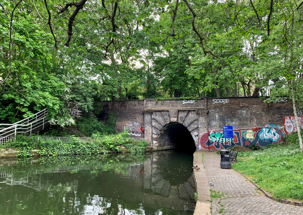
Running down the side of the pub is Duncan Street – and if you have the time and energy for a short ten-minute extension then it’s worth walking down it for about 150 yards to Duncan Terrace at the bottom. The gardens that you see on the left and right that run down the middle of Duncan Terrace were created to cover the New River, the waterway we discussed earlier, which brings fresh water down from Hertfordshire into London.
At the very bottom of the street is Colebrooke Row and directly below is the Regent’s Canal and the start of the tunnel that takes it for just over a quarter mile to the other side of Islington High Street/Upper Street. Pass through the gate and walk down the short, steep path to see the canal and the entrance to the tunnel. (The canal runs from the River Thames at Limehouse to Paddington.)

Retrace your steps back up Duncan Street to the York pub then turn right, continuing now along the narrower Islington High Street (not the considerably wider main Upper Street). Look up at the front of the house on the corner and you’ll see an old sign that says, ‘Islington High Street leading to Camden Passage’, which is where we are heading.
(And from here look across to the other side of Upper Street and notice the raised pavements – these were built to help ladies who were out doing their shopping to avoid stepping into the piles of animal dung caused by the huge numbers of cattle that were brought along the street en route to Smithfield Market.)
The unusual brick building in front of you that sits between Upper Street and the pedestrianised Islington High Street (currently a Sofa shop, but I doubt for much longer) was once London Transport’s ‘transformer station’. It subsequently became an antique mall, though sadly now just a furniture shop.
Whilst the road bends to the left we continue on down the narrower, pedestrianised Camden Passage – which is where some of the interesting little shops and restaurants really begin. The lane on the right, called Pierrepont Row, has an open space on the corner, where there are usually a few market stalls; it’s the site of a house that was bombed in the Second World War and never rebuilt. The little market is open on Wednesdays and Saturdays and usually has an interesting selection of antiques or books, depending on which day it is.
Look to your left when you reach Charlton Place and on the other side of Upper Street you can glimpse the enormous Business Design Centre, which we see later.
Continue on up Camden Passage – and look out for No.43 on your left: the window contains a fascinating collection of antique games, toys and fun curios. Apparently, it’s not actually a shop, but the home of a collector. He’s clearly got a great sense of humour!
I love some of the quirky and unusual shops and eating places in the passage – everything from a Japanese tea shop and opposite a Japanese art shop; a shop just selling speciality cheeses, whilst others offering vintage clothes and antiques … all good for browsing. (I just hope these independent shops survive so that the high-fashion chain shops with deep pockets don’t start moving in.)

When we reach the Camden Head – a traditional pub that opened in 1899 with a popular outside terrace that serves decent pub food – we’re going to turn to the left, up Camden Passage. At the top is the Essex Road and across it the miniature Islington Green, which divides it from Upper Street, which forks to the left at the point.
Cross over the busy Essex Road at the traffic lights that are just to your left (the street is so named because that’s where it leads) and on the green in front of you will see an imposing statue to Sir Hugh Myddelton, founder of the New River Company.
From the green continue on across Upper Street then walk down to the left.
After a few yards you reach Berners Road. Take a look up to the right and you can see the Business Design Centre and to the right of it is the Hilton Angel Islington.
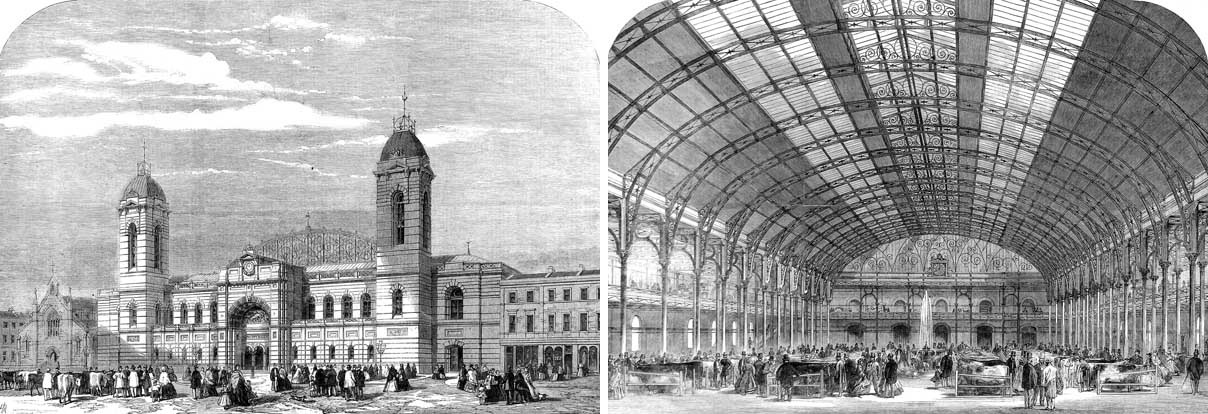
The design centre is used for many exhibitions and is built on the site of the huge Royal Agricultural Hall. This extends through to the Liverpool Road behind, though there is no public access from that side. (To see it you have to walk to the right up Berners Road, right again into Bromfield Street, right again into Liverpool Road – so unless you are keen on architectural history, I suggest you don’t bother.)
Continue on down Upper Street for a few more yards until you come to a pedestrianised lane between more modern shops (there’s a sign above that says, ‘Angel Central’), which leads through a shopping and cinema complex into Liverpool Road, where there’s yet more shops.
Liverpool Road was known as the Back Road and was primarily a ‘drovers’ road’. Animals that were being brought to London from the north and east, sometimes for huge distances of hundreds of miles, would rest and be fattened here before going on to Smithfield Market. The fields on either side were used for grazing, and pens and sheds were erected.
Finish: Angel station |
Continue on down Liverpool Road (you’ll see the old Chapel Market over on your right) until after a couple of hundred yards it joins Upper Street.
Cross over Upper Street and turn to the right for the Angel tube station or to the left for buses – there are a number of different routes from the row of bus stops here, including numbers 19, 30, 38, 73, 341, 476.
I hope you’ve enjoyed the walk. Please let me know your comments, criticisms, suggestions, etc. It really does help.