
 |
Updated: 23 February 2026 |
 |
Length: About 2½ miles |
 |
Duration: Roughly 1½ hours, depending on number of stops |
 |
Appendix: Click to view |
 |
PDF: Click to download |
A walk along the South Bank
“People don’t fall in love with the buildings; they fall in love with the things made possible because of the buildings.”
Dennis Crompton, one of the original architects of the Southbank Centre
VISITING
- Westminster Bridge

- County Hall

- London Eye

- Festival Hall

- Waterloo Bridge
- Book Market

- BFI Southbank

- National Theatre

- Gabriel’s Wharf

- Oxo Tower

- Doggett’s pub

- Blackfriars Bridge
- Bankside Gallery

- Tate Modern

- Southwark Bridge
- Borough Market

- London Bridge
- Hay’s Galleria

- HMS Belfast

- Tower Bridge

 |
Start: County Hall |
 |
Finish: Tower Bridge |

GETTING HERE
The two main ways of getting to the start of the walk are by bus or tube to Westminster Bridge, or Waterloo station.
WESTMINSTER BRIDGE
Arriving at Westminster Underground station
Westminster tube station is served by the Circle, District and Jubilee underground lines. Numerous buses also stop in the area.
Leave station by Exit 4, (opposite side of the road to ‘Big Ben’ and Houses of Parliament) and head towards Westminster Bridge.
Cross the bridge and walk down the steps in front of the enormous County Hall building, where the walk starts.
Notice the stone lion near the top of the steps. It was made from Coade artificial stone and from about 1837 it stood on the parapet of the Lion Brewery. The brewery was badly damaged by fire in 1931 and bombed in the Second World War, then demolished to make room for the Royal Festival Hall.


WATERLOO
Arriving at Waterloo Underground station (Northern, Bakerloo, Jubilee and Waterloo & City lines)
Exit the station in York Road, turn right and immediately right again into a pedestrian walkway. Walk to the end, cross over and continue on past Jubilee Gardens. After a couple of hundred yards turn right up the wide walkway alongside County Hall.
Arriving at Waterloo National Rail station
Waterloo station is served by train services from the south and southwest of England.
Leave the station by the main exit (Exit 5) on the left of the station, through Victory Arch. Go down the steps, (look back though to see the magnificent frontage) and walk down the sloping roadway. At the bottom turn left along York Road, cross over and just past the tube station entrance/exit turn right along the pedestrian passage. Continue on using the directions for arriving at the tube station.
It’s worth pointing out that if you follow the signs to the South Bank this may take you further along from where the walk starts. In which case, turn left and head for the London Eye – you can’t miss it – and County Hall.


STARTING THE WALK
The walk begins in front of County Hall on the riverside, immediately beside Westminster Bridge.
County Hall was built as the imposing headquarters of London County Council in a prime position just across the river from the Houses of Parliament.
Designed in a style of Edwardian architecture that Philip Howard, in his excellent book London’s River, describes as “a splendid example of Edwardian baroque at its most baroque, out-baroquing the Italians.”
Work on the building began in 1911, though delays caused by the First World War meant it wasn’t completed for another eleven years. When it opened, the building had over 1,200 rooms and 5¾ miles of corridors, with 7,000 staff, 92 councillors and 15 aldermen being based there.
In 1965, the LCC was succeeded by the Greater London Council, which then covered a far wider region. However, in 1986, the Conservative Prime Minister, Maggie Thatcher, became fed up with her plans for London being voted against by the councillors, many of whom were Labour Party supporters, and disbanded the Council. In its place she set up a more regionalised structure of boroughs and as a result, for a number of years the building was empty.
After being left empty for a number of years, County Hall has since been redeveloped and fortunately, its Grade II heritage listing has ensured its principal architectural features have been retained. If you look up at the central section, you can still appreciate its magnificent curved frontage.
Today it’s become a major leisure complex. It has two hotels and a number of tourist attractions, including The Paddington Bear Experience, The London Aquarium, Shrek’s Adventure and the London Dungeon. There’s also a Japanese restaurant, a fish and chip café and public toilets.

Continue on towards the London Eye, which opened in 2000 to celebrate the new millennium. At 442-feet high and said to be the highest in Europe, it has 32 capsules – apparently one for each of London’s boroughs. One complete revolution of the wheel takes just over half an hour. At the top of the revolution, you are some 440 feet above the ground – and on a clear day (not much point doing it if it’s not!) you can see for up to 25 miles. Originally it was sponsored by British Airways, but more recently other companies such as Coca Cola (2015–20) and lastminute.com (2020–25) have taken over.
The London Eye was only intended to be a temporary structure, and the original lease was for just five years. And it’s worth mentioning that when it opened it wasn’t popular with some people! The Chairman of the Royal Fine Art Commission called it a ‘miserable wheel’, whilst past leader of the Labour Party, Jeremy Corbyn MP, called it a ludicrous Ferris wheel.
However, before you rush aboard, I read in the Sunday Times that in the event of a problem, the only way back to the ground is by abseiling! They reported that in the early hours of a November morning in 1999, just weeks before it opened to the public, nine amateur abseilers were seen descending the 442 feet drop by rope from the top capsules. As one of the engineers behind the building of the Eye said, “I don’t feel we’d be able to do it these days.” What a terrible indictment of today’s health & safety paranoia.
And if it hadn’t had been for the Sunday Times, the wheel would never have been built. Julia Barfield, the architect who created the attraction alongside her late husband, came up with the idea as a response to a competition for a millennial landmark set by the newspaper and the Architecture Foundation in 1993. However, the competition’s jury dismissed their idea as it was just ‘temporary’. Not wishing to give up, they persuaded British Airways to help bankroll the project and later brought in the people behind Madame Tussauds, the famous London ‘waxworks’ attraction, for their additional expertise. Three years’ work had to be squeezed into a 15-month timeframe. Parts were built in factories across Europe, then barged across to a floating platform in the Thames, where it was erected like a giant Meccano set.

Next are the Jubilee Gardens that opened on the site of the 1951 Festival of Britain to celebrate Queen Elizabeth II’s Silver Jubilee in 1977.
The land had previously been the site of the Government India Stores Depot. Goods purchased by the British Government that were to be sent to India were stored here prior to being shipped. It had also been the site of the Lion Brewery that opened here in 1836. They were very well known for the quality of their IPA beers (IPA standing for India Pale Ale) which were specially brewed for the overseas market. It was heavy on the hops and usually had a higher alcohol content.

They are still called the Jubilee Gardens but were so badly damaged during the construction of the Jubilee Underground line that it was decided to revitalise the area and use the site for both Queen Elizabeth II’s Diamond Jubilee celebrations as well as the 2012 London Olympic Games. It provided a free viewing area during the Games.
To redevelop the site, the Dutch landscape architects who were brought in introduced meandering paths, seventy new mature trees, flower beds and a children’s play area.
Still within the park is a memorial to the many International Brigades fighters who lost their lives in the Spanish Civil War between 1936 and 1939. A paving stone was also placed here in memory of John Dimmer, who won the Victoria Cross in the First World War.
If you are interested in finding out more about the history of the gardens, then I suggest you take a look at the excellent ‘London Inheritance’ website article.
Next is a brightly coloured ‘Golden Carousel’, said to be an exact replica of the traditional English carousel that was at the 1951 Festival of Britain Pleasure Gardens in Battersea Park. Carousels were once a common attraction at fairgrounds and public parks in Britain and the rest of Europe from the 1700s onwards.
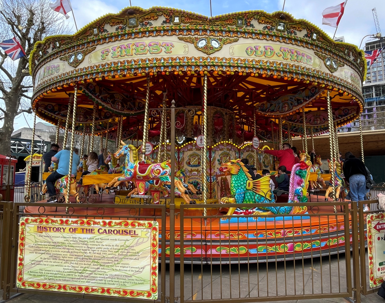
Immediately after the carousel, go past the steps that lead up to the Hungerford Bridge. It’s sometimes known as the Charing Cross Bridge, as it takes trains into the Charing Cross Station across on the north bank.
On either side of the railway bridge are the two Golden Jubilee pedestrian bridges that opened in 2002 as part of the celebrations for Queen Elizabeth II’s 50th anniversary. They replaced the bridge’s original narrow walkways that by then were in a very poor condition and the new bridges were a category winner in the Royal Fine Art Commission’s ‘Building of the Year Awards’.

The original railway bridge and a narrow pedestrian walkway had been built by Isambard Kingdom Brunel in 1845, but some years later it was replaced by a steel-span bridge designed by Sir John Hawkshaw, using cable deck-stays anchored onto Brunel’s original buttresses. The original suspension chains were reused to complete the Clifton Suspension Bridge in Bristol, which was also designed by Brunel.


Ahead of you on the right is the enormous building containing the Royal Festival Hall, which opened here in 1951 as part of the Festival of Britain. It’s the only building to have survived as the others were dismantled the following year. The festival was designed to demonstrate Britain’s recovery from the grim years of the Second World War, as well as to highlight the best of British efforts in science, technology, arts and design. I rather like the comment made by Clement Atlee, who was the Prime Minister in 1949 when the foundation stone was laid, ‘this new concert hall will show that we’re not just a nation of shopkeepers, but a people who appreciate and practise the arts’. It was certainly a success, with 8.5 million visitors within five months of it opening.
The Festival Hall is now part of the Southbank Centre, arguably Europe’s largest arts complex (though the Barbican Centre also makes this claim), and attracts over four million visitors a year.
It’s free to enter and I do suggest you take a look inside. (Note – it no longer opens on Mondays.) To visit, keep to the right and just past the steps that lead up to the bridge, walk up the ramp.
First, a little more about the building. It’s designed in the ‘modernist’ style of architecture, using reinforced concrete, and the bright white exterior was intended to contrast with its smoke-blackened surroundings. The large glass areas allow light into the interior, whilst at night it illuminates the outside.
Designed by a group of ‘radical young architects’ working for the London County Council, led by Norman Engleback, it was the first post-war building to be given a Grade I heritage listing. The building you see today has been enlarged and modernised since the original opened, with the 920-seat Queen Elizabeth Hall and the smaller 295-seat Purcell Room being added, together with the Hayward Gallery and the broad raised terrace that connects them to the original building.
These new buildings were designed in the brutalist style of architecture – not everyone’s favourite style, but I do happen to like it, and we see more examples when we shortly reach the British Film Institute and National Theatre.
The term ‘brutalism’ comes from the French words béton brut, meaning ‘raw concrete’, probably via the Swedish architectural term nybrutalism – ‘new brutalism’. The style was foreshadowed by the work of the modernist architect Le Corbusier and pioneered by several British architects from the mid-1950s.

To visit, enter the front of the Festival Hall building from the upper riverside terrace, walk along the right-hand side of the building with a line of restaurants on your right and use the entrance near the bust of Nelson Mandela. (It was originally made of glass-fibre but was recast in bronze as a result of repeated vandalism.)
You enter on Level 2 – an enormous spacious area with a large open-plan café and bar, serving coffees and teas, sandwiches, cakes, etc., with plenty of seats and tables for customers and visitors. Along on the left side there are excellent toilets. Also on this floor is a gift and souvenir shop and the main concert hall. The hall seats 2,700 and is cleverly designed to be cocooned from outside sound, particularly that from the trains crossing the adjacent railway bridge. What is fascinating is the shape of the private boxes, which are described as being like ‘pulled out drawers’.
There’s certainly a feeling of space throughout the building. Symmetrically placed staircases and galleries, with bars and restaurants in the wide-open foyers are designed to give ‘meeting places for everyone’.
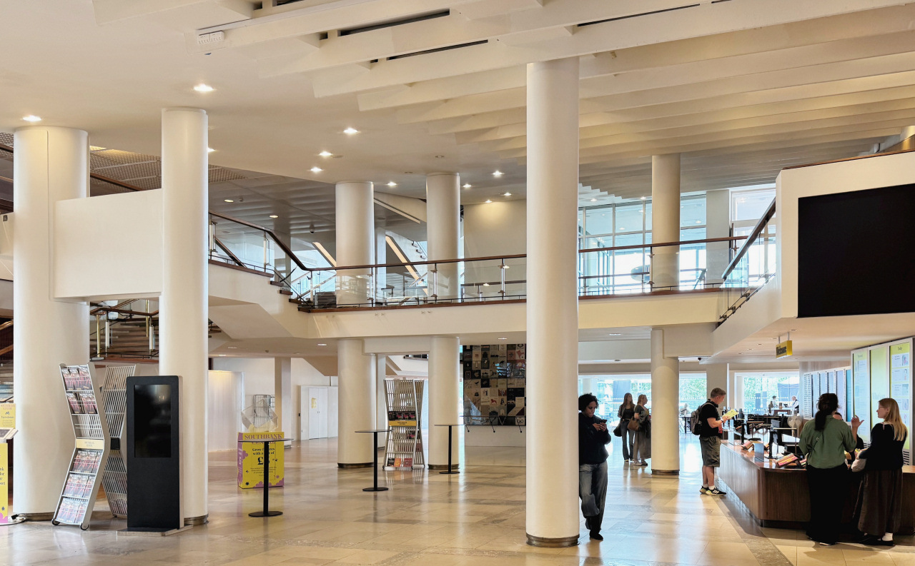

Level 3 has the popular Skylon restaurant with a bar in its centre. It serves ‘modern British cuisine in a relaxed atmosphere’ and floor to ceiling windows give good views of the river. Originally called ‘The People’s Palace’, that was changed in 2007 to ‘Skylon’, the name of a towering sculpture in the original Festival of Britain.
On Level 5 is the Balcony Bar and Terrace with views across the river. Also on this floor is the National Poetry Library, which has been located at the Festival Hall since 1988. It is described as the ‘home of the spoken word’, and various literature events, including dramatised readings of iconic novels, take place here.
Level 6 has the St Paul’s Roof Pavilion and a members’ area.
When you’re ready to move on, I suggest you don’t use the same stairs that brought you up from the river level but instead turn right along the wide raised walkway to the Queen Elizabeth Hall.

The Queen Elizabeth Hall features a range of music that besides classical concerts have included Ella Fitzgerald and Louis Armstrong. The Purcell Room, which was named after the 17th-century English composer Henry Purcell, offers concerts for chamber music, jazz as well as mime and poetry recitals. Artists such as Frank Sinatra, Jimi Hendrix, Marianne Faithfull and David Bowie have performed here.
Behind the QEH is the Hayward Gallery – notice the glass pyramids on its roof (apparently there are sixty-six, though I haven’t counted them!) that form quite a feature of the building. A description I read said, “the serrated glass roofscape offers a material contrast to the concrete forms below.” It went on to say that, “in spite of the ingenious use of lighting baffles to provide indirect daylighting to the upper galleries, the glazed pyramids never quite delivered. Their thermal performance was poor and the fabric began to fail quite quickly.” Whilst measures were taken to manage these failings, “the end result was artificially-lit galleries, far from the original intention.” Replacement rooflights were installed in 2017.
As with all of the Southbank Centre buildings, the Hayward Gallery is free to enter and besides the galleries there’s a gift shop and of course toilets!


If you look across the river to the north bank, then behind the railway bridge you can see One Embankment Place, the enormous office development that was built over the top of Charing Cross station in the late 1980s. Further to the right is the 1931 Shell Mex House with its famous clock. You can also see the art deco-style Adelphi office building that opened in 1938, whilst in the foreground are the Victoria Embankment Gardens with Cleopatra’s Needle on the riverbank.
When you’ve finished looking around, take the set of yellow iron steps back down to the river level and the Festival Pier.
Under the building is the brightly coloured Southbank Skateboard Park that was built in the undercroft. (You’ll probably hear it before you see it!) Although it’s been here for over forty years it was never intended to be a skatepark – it was just an open ‘leisure space’. However, skateboarders were quick to realise its potential and it’s fascinating to watch the skateboarders practising here – some of them are quite amazing.
After the Skatepark comes the BFI Southbank, which is underneath Waterloo Bridge.
Both the BFI and the National Theatre, which we see next, are good examples of the brutalist architecture that I mentioned earlier and I suggest you at least take a quick look inside.
The BFI Southbank (also known as the National Film Theatre) is fronted by a large café and bar. Despite its brutalist exterior, the inside is surprisingly comfortably carpeted and pleasant to walk around. There are four cinemas that you reach by walking through a long, winding corridor to the rear of the building. Also at the rear is a café and another bar, as well as an excellent shop selling a wide range of books and gifts related to the cinema, with a huge collection of DVDs.
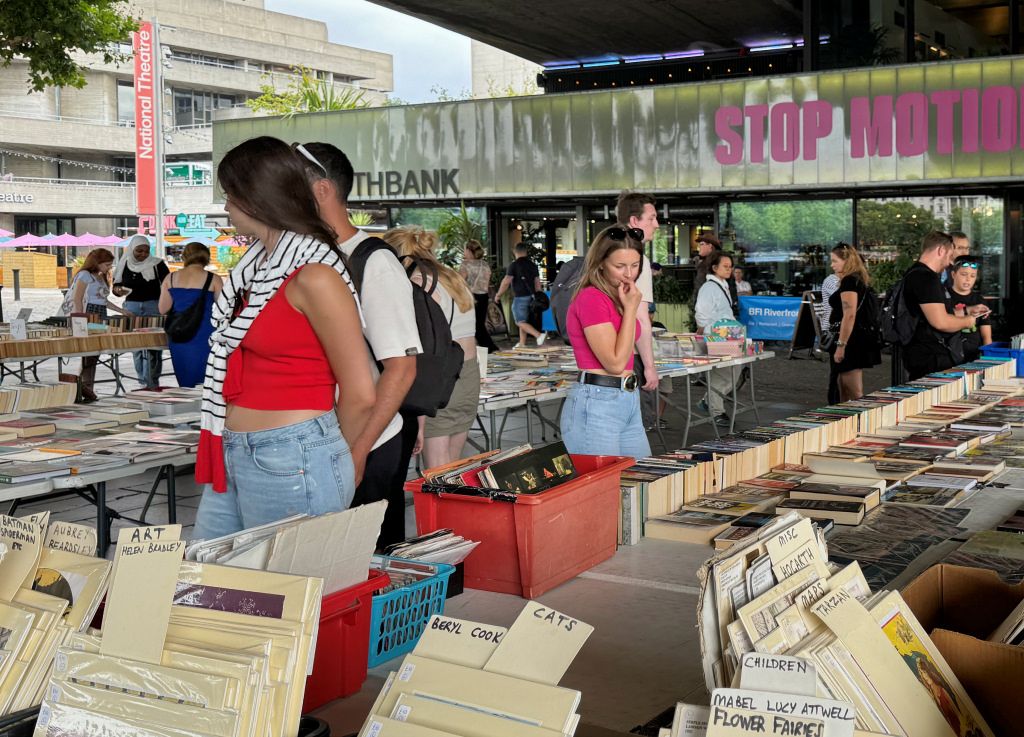
Until the 1980s, the river walkway ended here at Waterloo Bridge, but it’s since been extended all the way to Tower Bridge.
Also underneath Waterloo Bridge is the open-air South Bank Book Market. It has been operating here for over forty years, offering books ranging from contemporary fiction, vintage and antiquarian editions as well as a selection of prints and maps. It was the ‘brainchild’ of Leslie Hardcastle, who in 1983 was the Controller of the BFI (British Film Institute). He wanted to bring some life to the dark and empty space beneath Waterloo Bridge. It is normally open daily between 10am and 7pm, though not all stalls are open every day and it can be weather dependent. Weekends are always a good time to visit.
Waterloo Bridge is the second bridge on the site. The first was built in 1817 by the Scottish civil engineer John Rennie. It was originally to have been called the ‘Strand Bridge’ (‘Strand’, from the Old English strond, meaning ‘shore’, being the road that ran alongside the north bank of the Thames) but as it opened on the second anniversary of the British victory at the Battle of Waterloo the name was changed.
It had nine arches, each with a span of 120 feet and was described by the Italian architect Antonio Canova as the “noblest bridge in the world.” He added that it was worth travelling to England just to see the bridge!
Unfortunately, the bridge had serious structural problems and after many arguments between conservationists, who loved the old bridge’s beautiful design, and users of the newly motorised vehicles who weren’t allowed to cross it because of its problems, a new bridge was eventually agreed upon.
The new bridge was built by the renowned architect Giles Gilbert Scott and consists of five 250 feet arches. It was often referred to as the ‘Ladies Bridge’ as it was built by a predominantly female workforce, because so many of London’s male workers were supporting the war effort. Sadly, very few of the female workforce were invited to the opening ceremony.
The view from the bridge was immortalised by the ’60s pop band The Kinks, in their song ‘Waterloo Sunset’.


As you emerge from under Waterloo Bridge you see the National Theatre (officially the Royal National Theatre). Designed by Sir Denys Lasdun, it’s another of the South Bank buildings built in the ‘brutalist’ style of architecture. Lasdun is perhaps not that well-known these days, yet he was one of Britain’s most important architects in the 1950s and 60s. He particularly liked working with concrete, which he said “can be a beautiful material if it is used in the way its own nature intends it to be used … it is a sort of sculpture … it is not a cosy little material.”
The National caused quite a controversy when it opened. The composer Sir Thomas Beecham remarked, “I question whether in three hundred years there has been a more unattractive, ugly and more monstrous structure …” And Prince Charles (as he was at the time) must have felt something similar, saying it seemed like “a clever way of building a nuclear power station in the middle of London without anyone objecting.” I personally like it, as did the poet laureate and architectural critic John Betjeman, who wrote a letter of praise to Denys Lasdun.
A huge, illuminated scrolling sign on the roof of the building, which can be seen from the other side of the river, advertises ‘what’s on’ in the theatre. In the wide area in front of the building there’s a statue of Laurence Olivier, who was a founding patron of the National Theatre. There’s also a statue of two women called ‘London Pride’ that was created by Frank Dobson CBE (1886–1963) for the opening of the Festival of Britain in 1951.


The entrance to the theatre complex is in the protruding section on the left and, as with the other Southbank Centre buildings it is amazingly spacious inside. Seats and little tables are scattered around and during the day, when the theatres are perhaps not necessarily in use, it can seem remarkably empty. It was clearly built at a time when space wasn’t at such a premium as it is today.
On the first floor (you reach it by a lift or stairs) there is plenty more open space as well as the Lasdun Restaurant & Bar. If you continue on up to the Second Floor you find the popular Forza Wine restaurant and bar. In good weather, the equally spacious outside terraces are ideal for enjoying a drink with excellent views.
But the main point of the building are the theatres – and there are three of them. The Olivier, the Dorfman and the Lyttleton, which between them can seat 3,500 people. It is said that within the theatres nobody is more than 65 feet away from the stage. I also find it impressive that there are 135 air-conditioned dressing rooms.
There is also an excellent book shop with a wide range of theatrical books and plays as well as cards and gifts.
Immediately next to the National Theatre is 76 Southbank (its actual address is 76 Upper Ground), another building designed by Sir Denys Lasdun in the same brutalist style of architecture. It was his last major project, which partly accounts for its Grade II heritage listing. Built as the British head office of the technology company IBM, who have since moved elsewhere, it’s currently (2026) subject to a massive restoration. The developers stress that 80 per cent of the existing structure will be retained and will offer 300,000 square feet of office space and 50,000 square feet of terraces.
I understand it is going to be London’s Centre of Science and Culture but, at the time of writing, it is still being marketed so I have no idea who all the tenants will be.


For many years much of the riverside after Waterloo Bridge was lined with derelict warehouses and wharves, most in a very poor state. Thankfully, that all changed in 1977, when it became the Queen’s Jubilee Walkway, and it is now a pleasant tree-lined stretch which at various times of the year hosts stalls primarily selling food and drink, as well as gifts and souvenirs.
The path now widens to become an excellent observation point with great views across to the north bank. If you look back to the north side of Waterloo Bridge, above the many buildings you can see the spire of St Bride’s Church in Fleet Street. The spire is famously said to be the inspiration for the many tiers that often make up a traditional wedding cake.
Looking further down the river is Blackfriars Bridge and station – you can see the solar electricity charging panels on the roof – whilst behind it on the left is St Paul’s Cathedral, with the skyscrapers of the City of London’s financial district in the middle.
On the waterfront here is Ernie’s Beach, another of the South Bank’s sandy stretches – at least at low tide. The beach is named after John ‘Ernie’ Hearn, a local activist who’d campaigned to help protect the foreshore from private property developers. These beaches are very popular with Londoners and visitors for sunbathing, playing games, walking dogs – and ‘mudlarking’. That’s the name given to searching for items washed up by each tide.
Anyone can access these ‘beaches’ – provided, according to the Port of London Authority (PLA), who together with the Crown Estates have legal responsibility for the foreshore, “they’re not searching in any way or for any reason. This includes all searching, metal detecting, ‘beachcombing’, scraping and digging.” To do any of these, you need a permit from the PLA, for which there is currently a long waiting list.

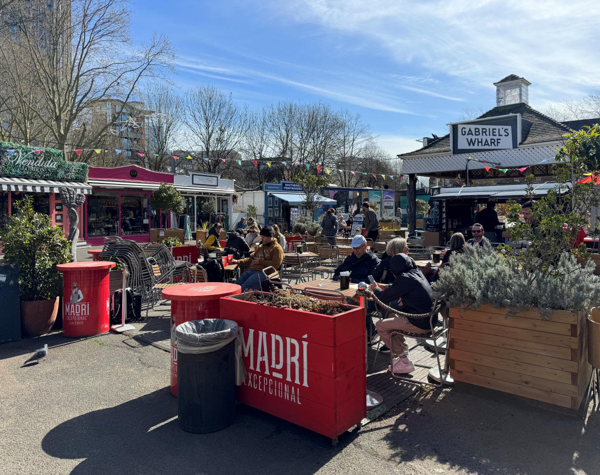
You’re now at the popular Gabriel’s Wharf – where on the right there’s a collection of shops selling jewellery, clothes and memorabilia, as well as several places to eat and drink. One of my favourite shops is the co-operative Southbank Printmakers Gallery.
The wharf gets its name from a family that ran a timber yard here for the best part of two hundred years. Although it closed over a century ago, many of us may still be familiar today with the family name through one of their descendants – the singer, songwriter and musician Peter Gabriel.
By the 1950s much of this area had become derelict and the local population had fallen from 50,000 to under 5,000. However, in 1988 a project was launched to redevelop Gabriel’s Wharf that involved the local community organisation Coin Street Builders and Urban Space Management, the successful developers of local markets in London, including the one at Camden. It opened in just three months and such was its success that it paid for itself in four years! This was part of the catalyst of the transformation of the area.
This was also the site of the famous London Weekend Television studios that had been here for nearly fifty years and were home to many popular programmes, including Upstairs Downstairs, Blind Date, Game for a Laugh, Ant & Dec’s Saturday Night Takeaway, The Dame Edna Experience, On the Buses and World of Sport.
To the dismay of many in the television business, the studios closed down in 2018, with activities being transferred to the Television Studios at White City. The building was finally demolished in 2025, just whilst I was finalising this walk. The site was sold to the Japanese property developer, Mitsubishi Estate. According to the website of Multiplex, the company responsible for building the new development, it will consist of a 25-storey office building, connected to two further buildings, one of 14 and the other of 16 storeys. To me at least, 25 storeys is obscene in such a landmark situation. Surely more appropriate to being in the financial district on the other side of the river or in Canary Wharf. But sadly of course, these days it seems that the aim is to make as much money as you can out of development and to hell with the consequences for everyone else. As if to make it all sound better, their website goes on to talk about three floors being allocated for a “multi-level cultural and innovation hub … providing 40,000 square feet of affordable workspace for the creative industries …” Hmm, so that’s OK then? However, these are only my own views – others may welcome the new development as being part of the progress that has been a factor in London’s phenomenal success over two millennia.

A final point on Gabriel’s Wharf – on my last visit there before this walk was published, one of the stallholders told me that they have been provisionally advised that the whole site will be cleared, which I guess will be the end of Gabriel’s Wharf as we know it. If it is true (as it seems to be), then it will be very sad. This is an iconic site.
Immediately after Gabriel’s Wharf you’ll see an old wooden jetty on the riverside. Here are the Bernie Spain Gardens. These small gardens (there are two of them) were transformed from derelict industrial wasteland and named after Bernadette Spain (1936-84), a local resident and founder member of the Coin Street Action Group, which I explain more about shortly.
Bernie, who was a clinical psychologist, was said to have epitomised the motto of her school – ‘Women in time to come will do much’. She worked tirelessly to challenge inequality in health and housing and her work with the Coin Street Action Group in the 70s and 80s did so much to save and improve the area in which she lived.

Ahead of you now is the iconic Oxo Tower – but first, if it’s a low tide you’ll see another sandy beach, with the stone and wood remains of what was once the causeway of the Old Barge House Stairs. The stairs’ name comes from their proximity to the King’s Barge House where in the 16th century Henry VIII’s barge was kept.

The Oxo Tower is one of South Bank’s most distinctive buildings, and a well-known London landmark.
The windows of its tower have the letters O X O picked out in the brickwork and ‘windows’. Back in 1929, the owners of the Oxo brand had wanted to have an illuminated sign to promote the name. However, permission for this was refused as advertising wasn’t allowed on buildings here, so the three letters were incorporated into the actual building instead. As this was an architectural feature, they were allowed to go ahead. What an amazingly clever idea!
The sign on the entrance to the buildings explains its current use rather well, ‘Welcome to the heart of creative London – home to dozens of independent design studios and artisans’. Spread over three floors, many are run by the artists themselves. The building is also known for its rooftop bar, restaurant and viewing gallery.
The building was originally a power station for the General Post Office. It was bought in the 1920s by the Liebig’s Extract of Meat Company, who built the tower and a cold store behind the power station’s original façade, which is what you still see today. The company imported meat, especially from South America, that was stored and distributed from here. They of course also manufactured Oxo meat extracts and stock cubes.
During the 1990s, much of the building underwent a massive renovation, with the upper floors of the warehouse being converted into apartments and a range of specialist shops, galleries and of course the famous restaurant.
If you’d like to visit the rooftop bar, brasserie and restaurant, which have a 250-foot garden terrace offering excellent views across the Thames, take the lift from the rear of the building to the eighth floor. (There’s also a free small public viewing gallery – head for the bar/restaurant reception desk, turn right and follow the glass-walled corridor through two doors and onto the little terrace.)
Whilst within the building there are a number of small specialist shops, many selling the products of particular artists. I personally like the Brand Academy Store, a large shop on the ground floor at the far end of the building. It’s packed with novelties of all shapes and sizes and prices. Some just for children, some you wonder why anybody would ever buy them, but in between some great fun objects. According to its website, the store “hosts a collection of the world’s greatest brands and emerging talent, standing side by side in the iconic Oxo Tower. Brand Academy is a unique platform enabling artists and designers to showcase their products to the public. The revenue generated by the established brands contributes to the support and aid given to the designer makers enabling them to derive an income and fulfil their dreams.”
And by the way, it sells the cheapest coffee I saw on the South Bank!

I’ll just add that behind the Oxo Tower is the well-preserved Barge House, though not the one the King’s Barge was kept in. It’s a good example of the many hundreds of riverside wharf buildings close to the banks of the Thames and is now mainly used for exhibitions, performance spaces and much else.
Walking on from the Oxo building you pass the Beach House Terrace, part of the enormous Sea Containers House. The building was constructed in 1974 and designed by an American Modernist architect in the style of a 1920s transatlantic cruise liner. Originally it was intended to be a luxurious hotel, but during its construction it was felt that it would be more profitable as offices. Then in an about turn in 2011, it was decided to convert part of the building back into a luxury hotel. The rest of the building was taken over as offices by WPP, one of the world’s largest communications companies.
The hotel’s Lyaness Bar on the ground floor is said to be ‘one of the best cocktail bars in the world’ and created by Ryan Chetiyawardana (known as Mr Lyan) and called the ‘World’s Most Awarded Bartender’ by The Telegraph newspaper.
 Whilst it has nothing really to do with the building, I’ll just add a piece of information that I found fascinating. The business of transporting goods, particularly at sea, in containers was started by an American trucking entrepreneur named McLean in 1958. He put fifty-eight of his trailer vans on to a ship and sailed them from Newark to Houston in Texas. And the company ‘Sea Containers’ was formed by James Sherwood, a retired US Navy officer in 1965. His business interests grew to include several train companies, including the British ‘Great North East Railway Company’ and the luxury rail and hotel company ‘Venice Simplon-Orient Express’. Sadly, the company went bankrupt in 2006 after failing to make a $115 million dollar debt repayment to bondholders.
Immediately ahead is Blackfriars Bridge – but first there’s what I feel is a poorly designed residential building, considering it’s in such a prime site. Look up to the right and you’ll be able to see the enormous One Blackfriars apartment building that opened in 2018. It’s unusual shape – said to have been inspired by an artistic piece of 1950s of Scandinavian glass, and almost five and a half thousand glass panels – means it’s been nicknamed ‘The Vase’. Besides the main building, there are two smaller adjacent buildings in the complex. In addition to the apartments, the development also includes the Bankside Hotel.

Next to it is the Doggett’s pub. Its full name is ‘Doggett’s Coat and Badge’ and not surprisingly, people often wonder how it got such an unusual name.
The pub is named after Thomas Doggett, who used to organise a rowing race from London Bridge to Chelsea. First held in 1715, it is said to be the oldest continuous sporting event in the UK. It takes place every July and runs for just over four miles. The winner is awarded a Waterman’s coat and badge, hence the name ‘Doggett’s Coat and Badge’. Doggett died in 1721 and left instructions in his will for the race to be carried on by The Fishmongers’ Company (one of the City of London’s Livery Companies), which it still is today.
The top floor of the pub is reserved for those having a meal, but the floor below is open for drinkers to also enjoy the view of the river. There’s also a pleasant terrace in front on the ground floor – but you need to place your order inside the pub.

At low tide you can see another of the South Bank’s sandy beaches here, with steps accessed through a gate.
At low tide you can see another of the South Bank’s sandy beaches here, with steps accessed through a gate.
Before you go under the underpass, look across to the north bank and to the left of Blackfriars Bridge is an unusual building – unusual particularly because of the columns on its frontage. It’s the Unilever Building – sometimes known as the ‘House that Soap Built’ as originally it was the headquarters of Lever Brothers, who made their money producing soap. Built in a neo-classical art deco style in 1931, this was originally the site of the Bridewell Palace, and later De Keyser’s Royal Hotel.
If you’d like to know more about this fascinating building, and its equally fascinating history, then you might like to take a look at this excellent article on the Memoirs of a Metrogirl website – one of my favourites of the many websites that look behind the history of so much of London.
Blackfriars Bridge was the third bridge across the Thames – the first was London Bridge (which we see shortly) whilst the second was Westminster where our walk started.
It was opened in November 1869 by Queen Victoria, who was clearly having a busy day of bridges as having opened Blackfriars she then crossed over and travelled up Farringdon Road to open the Holborn Viaduct.
This is the second bridge on the site. The first opened in 1770 and was known as the Pitt Bridge, named after the 18th century Prime Minister William Pitt the Elder. However, by the middle of the 19th century, the stonework foundations were discovered to be eroding, and it was demolished. Today’s bridge is largely constructed of wrought iron.
The bridge is now wider than when it was first built as extra road space was added in 1909 to enable trams to cross.
Walk through the white tiled passageway under the bridge – notice the pictures and information on the earlier bridges on the walls.

As you come out of the pedestrian tunnel, and before you pass under the railway bridge, walk up the short flight of steps on the left. You get an excellent view of the road bridge on the left and on the right the railway bridge that is now also Blackfriars station. On the side of the bridge is a large sign that says, ‘London, Chatham and Dover Railway’, a reminder of the original, which was demolished in the 1980s. You can also see the pillars of that bridge which were left in the river when the original was demolished. Wikipedia has more on the London, Chatham and Dover Railway.
Currently (2026) the path continues under temporary scaffolding, part of the enormous Bankside Yards development.
Many fear – and I do agree with them – that this will be another monstrosity of unsuitable design for such an historic riverside site. The development is spread over a 5.5-acre site, with various buildings, the tallest building rising 50-storeys and offering ‘247 apartments of spacious and timeless design’. It seems developers won’t be happy until the entire Southbank is one long strip of enormous glass and concrete buildings!
According to the developer’s blurb, Bankside Yards, is “the UK’s first fossil-free major mixed-use development.” However, I rather liked what the ‘Diamond Geezer’ wrote in his excellent blog –
“Hmm, I thought, for ‘the world’s first fossil fuel-free major mixed-use development’ … you don’t just knock down two brutalist 1970s office blocks and replace them with 650 flats, more offices and a hotel without letting rip some carbon somewhere. It turns out the buildings are only intending to be ‘net zero carbon in operation’ using a ‘5th generation energy network driven by electricity from renewable sources’ but marketing never lets full disclosure get in the way of a good strapline. A separate hoarding showed what the new Bankside Yards development will look like, which is a forest of towers beside the railway line including one particularly tall one. It doesn’t include the slanty one on the right-hand side of the image, but once you give planning permission for one such monster a cluster inevitably arises.”

As you come out of the ‘underpass’ take a look back at the wall and you can see an excellent painting of the river.
On your left, there’s a raised walkway that gives a better view of the river and the buildings on the other side of the river, notably a massive concrete office block called Baynard House. A mansion called Baynard’s Castle stood there until it was destroyed in the Great Fire of London, after which the site was occupied by a series of wharves and warehouses. Baynard House was built in the 1970s, alongside two equally nondescript office buildings: numbers 1 and 2 Puddle Dock. There are plans – which for once I support – to demolish and redevelop all three of these buildings.
One building in particular has an unusual feature – a ramp along its front, down which you can see vehicles driving. It’s White Lion Hill, a slip road that leads off from the main Queen Victoria west-east road to rejoin the Blackfriars underpass that actually wraps around the posh City of London School (a private boys’ school with fees when I last looked of nearly £8,000 a term) and then via a ramp drops back down to river level.
You do at least now have a splendid view of St Paul’s Cathedral as well as some of the skyscrapers of the financial district in the City of London. And just a little further down river is the Millennium Bridge, whilst ahead of you on the right is the tower of the chimney of Tate Modern.
At the end of the walkway is the FCB Coffee Shop, which I can recommend for an excellent coffee, sandwiches and other snacks.
There is now a pleasant tree-lined stretch with a large brick-built residential block of flats called Falcon Point. Built in the late 1960s/early 70s, there are 110 flats. It was originally local authority owned and, while some flats are still under social ownership, many others have been purchased by their tenants under the ‘right to buy’ law.
The name Falcon Point derives from the notorious Falcon Tavern that stood on the eastern side of the site from the 16th century until 1808. The inn’s proximity to the Globe Theatre has led some to speculate that Shakespeare used to drink there – as well as at a predecessor of the Anchor, which we’ll come to shortly.

Underneath the flats is a small newsagent and grocery shop.
In front is the Founder’s Arms, which opened here in 1980, with tables literally on the river’s edge. It is built on the site of a foundry, which was here at the time of Sir Christopher Wren. In fact, Wren is known to have lived close by whilst St Paul’s Cathedral was being built. The wrought ironwork that surrounds the high altar in St Paul’s Cathedral and which can still be seen today was made in the foundry here. Between being a foundry and a pub, it was also a hydraulic pumping station.
On the lower level on the left of the Falcon Point building is the Bankside Gallery.
It’s the home of the Royal Watercolour Society, which dates back to 1804, when it was called the Society of Painters in Water Colours, and the Royal Society of Painter-Printmakers. The latter had started in 1880 as the Society of Painter-Etchers, in reaction to the refusal of the Royal Academy of Arts to exhibit etchings and engravings. The Painter-Etchers received their royal charter from Queen Victoria in 1888. The society changed its name in 1991 to embrace a wider range of printmaking practices.
Besides regularly changing displays of art, the Bankside Gallery also sells ‘affordable original art’ in its shop, as well as a good selection of art-related books, and if you have time then I do recommend you taking a look. It’s open daily 11–6pm.
You’re now just a couple of minutes’ walk from Tate Modern; on your right you should be able to see its tall chimney as well as the Millennium Bridge directly ahead.

Just after Falcon flats, take one of the two pathways to the right and follow the sign for the Corner Bar. Walk around its outside seating terrace and follow the signs to the Turbine Hall.
Whilst you may not have time to fully explore the Tate on this visit, I do suggest that if nothing else you at least take a quick look inside the massive 32,000 square feet Turbine Hall. Once where much of London’s electricity was produced, today it is famous for the regularly changing artistic displays.

- Admission to Tate Modern is free, though they do ask visitors for a minimum £5 donation
- It is open seven days a week
- It opened in 2000 and since then over 40 million people have visited
- According to the Association of Leading Visitor Attractions, it is the UK’s fourth most-visited attraction (and the Southbank Centre is the fifth)
- There are two main buildings – the six-storey Natalie Bell and the ten-storey Blavatnik
- They are separated by the lower-level Turbine Hall – a bridge across the hall connects them
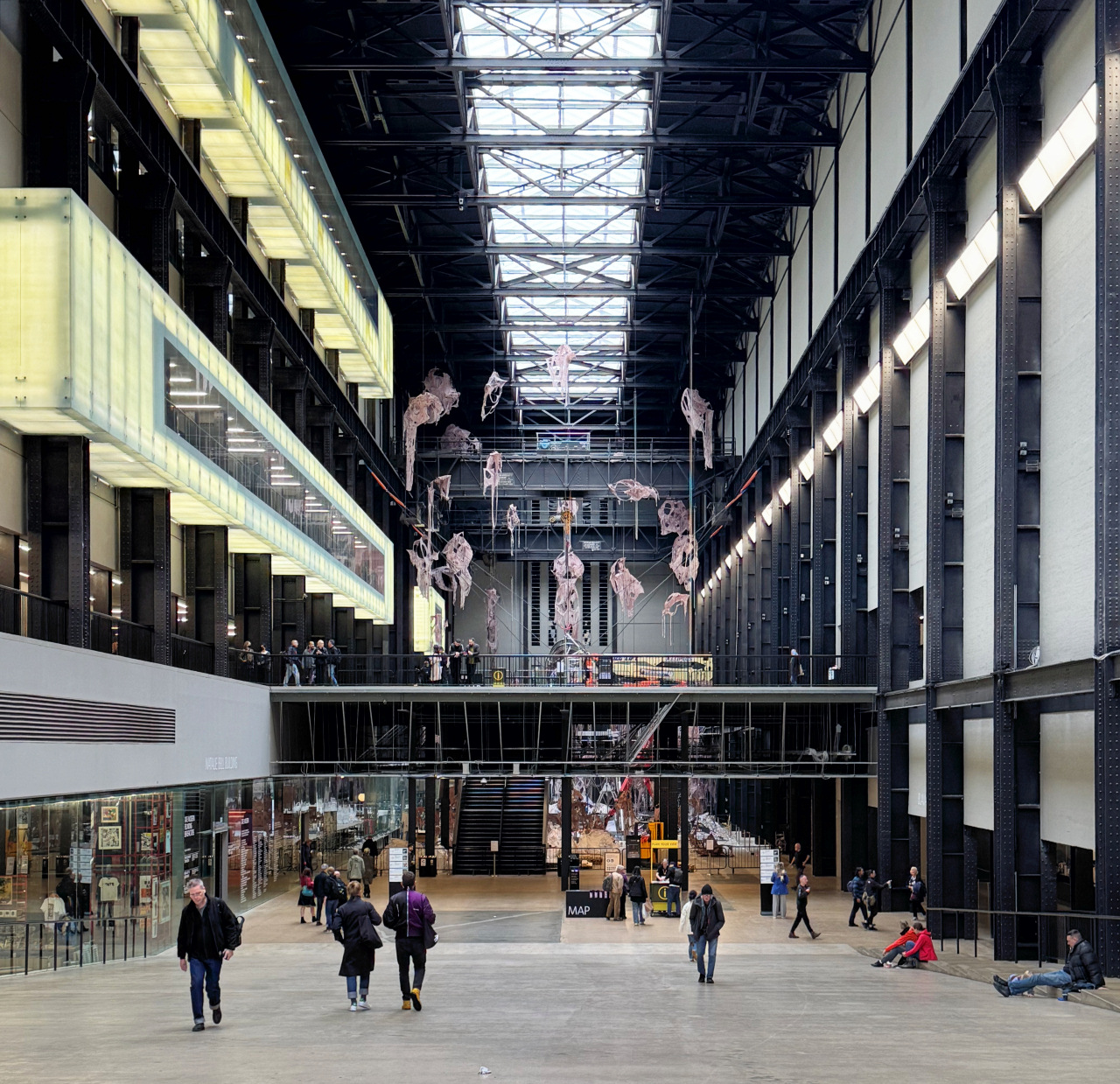
For a quick look walk down the ramp into the hall, and if this is all you have time to see, use the stairs on the left up to Level 1 where you can exit back to the river front.
However, to see a little more, turn left through the glass doors at the bottom of the ramp and take the escalator to the second floor on Level 2.
At the top of the escalator, you can walk through a multitude of rooms displaying a wide variety of modern art. When you’ve had enough, come back to this point and look for the signs for the lift or stairs to get down to the ground floor riverside exit.
If you have time and would like also to see into the adjacent Blavatnik building, then use the bridge that crosses the Turbine Hall. Pass through the gift shop, keep to the left, and you’ll see the lifts. On the top (10th) floor there’s a viewing gallery and the Expresso coffee shop.
In case you’re thinking, as I did, that Blavatnik is a somewhat unusual name, Len Blavatnik is a Soviet/Ukrainian born, British-American businessman, said to be the 76th richest person in 2025 with a net worth of $26.5 billion and who in 2017 was knighted for services to philanthropy. He gave a significant amount of money to fund this extension to Tate Modern.
When you’re ready to leave, go through the main entrance/exit on Level 1 of the Natalie Bell building, which takes you out onto the large garden area in front. (And if you’re wondering who Natalie Bell is, take a look here.)

After exiting Tate Modern, you pass under the pedestrian-only steel suspension Millennium Bridge which, as the name implies, was opened in 2000 – though only for a day! Unfortunately, people using it that first day experienced a rather scary swaying motion, which saw it nicknamed ‘the Wobbly Bridge’. It didn’t fully reopen for another two years.


The technical explanation for the problem was ‘unexpected lateral vibration due to resonant structural response’. What was discovered during extensive testing and research was that ‘people crossing a bridge with a lateral sway have an unconscious tendency to match their footsteps to the sway, thus making it worse’. (Not for quite the same reason, but similar in a way that military troops are not allowed to march across some bridges). You can read more about it here.
From here you get another good view of the cluster of skyscrapers of the City of London’s financial district, a view you will continue to see as you head down the river.

On the right now is a little row of houses known as Cardinal’s Wharf.
It was built on the site of the 15th century Cardinal’s Hat pub. The name was a result of Cardinal Wolsey (1473-1530) parading here wearing a red ‘Bishop’s hat’ after being made a Bishop by the Pope. (When in London he would have stayed in the nearby Winchester Palace).
Tallest of the houses is the cream coloured No.49. It has three-storeys, a red door and is the last survivor of what was once a long line of houses overlooking the water. Originally built in the 1500s and rebuilt in the 18th century, there’s a plaque saying that Sir Christopher Wren, the eminent architect, lived here whilst he was building St Paul’s Cathedral. However, apparently there is some doubt as to the accuracy of this. You do get a good view of the cathedral across the river from here though.
There’s a sign over the narrow passage next to number 49 explaining it is called ‘Cardinal Cap Alley’. It once led to a brothel that was mentioned by the diarist Samuel Pepys. It was gated in the 1990s (probably too many people wanted to know whether the brothel was still there!)
I highly recommend a book published in 2006 that is centred on the history of the house and how it fits in with the rest of Bankside – and indeed London. Called ‘The House by the Thames’, it is by Gillian Tindall.
Now Grade II listed, the house has been home to a number of famous people in the past – as well as many who weren’t so well-known. Among the better known were Hollywood actress Anna Lee and her husband Robert Stevenson, who was the director of several Disney films including Bedknobs and Broomsticks and Mary Poppins.
Called ‘The Deanery’, it is (or was) the home of the Dean of Southwark Cathedral. I was told the house next door is the home of the cathedral’s organist and Director of Music, but a while ago I saw a piece online saying that the owners, Southwark Cathedral, had put it up for sale in 2011 for £6 million.
The ‘Metro Girl’ has written an excellent piece about these houses and their history, which you can find here.
And another blog with an excellent piece about these houses is here.

Immediately next is the world-famous Shakespeare’s Globe Theatre.
You are normally able to walk up the flight of steps and through the iron gates (which as the sign says were opened on behalf of the men and women of the Ford Motor Company by their chairman in front of Queen Elizabeth II and the Duke of Edinburgh in 1997). This entrance will only allow access into the Globe when there is a performance. However, it is also an entrance into the adjacent Swan Inn, which I mention shortly.
And I must mention that if you look at the many paving stones slabs that have the names of benefactors who’ve donated money to the Globe restoration, you’ll notice one for Monty Python star John Cleese and another next to it for his fellow Python, Michael Palin. However, look carefully and you’ll see that Michael’s surname is spelt incorrectly, with two ‘l’s. This was deliberate; Cleese offered to pay for two paving stones – one for him and one for Michael on the condition that they’d spell ‘Palin’ incorrectly! Which, as you can see, they did!
This is not the original Globe of Shakespeare’s day – much of that is said to be buried beneath Southwark Bridge – but a reconstruction. It opened in 1997 and was built in a similar way to the original, using ‘green’ untreated oak, lime plaster reinforced with goat hair and bricks, and topped with a Norfolk reed thatched roof.
Today you can enjoy watching Shakespeare’s plays in the same way you would have in his time – standing or sitting on benches – and if it rains you get wet – just as you would have done back then! The Globe can hold 1,570 people, but if you want to save money, there is space for seven hundred people to stand. These unreserved standing tickets are cheaper – you’ll be known as a ‘groundling’, the name given to people who buy these tickets, as it was in Shakespeare’s time.
There’s an excellent website that enables you to see the view from individual seats before you book – you can find it here.
So much is written about Shakespeare and the Globe, plenty of it available online, therefore I’m only giving the briefest details here. However, I have written a little about why the actors moved across the Thames and built a theatre here.

For more information on visiting the Globe, take a look here.
In front of the Swan pub is the Bankside Pier, and an excellent observation point.
The Swan was built as an integral part of the new Globe complex and opened in 2007. Its popular restaurant, with a predominantly British menu, has excellent views across the Thames. It’s worth noting that a percentage of the Swan’s income goes to help support the Globe.
The pub’s website has a number of quirky pieces of information about the Globe, which I reproduce here:
- The Globe Theatre is the only thatched building that has been built in London since the Great Fire of 1666.

- The modern Globe Theatre was built using the same building materials and techniques that would have been around in Shakespeare’s time. One thousand English oak trees were carved using traditional methods to make the timber frame, and the walls are made of 36,000 handmade bricks, lime putty and cashmere goats’ hair.
- Different coloured flags were used to signpost what kind of play was being performed. White flags were raised for comedy plays, black flags for tragedies and red flags signalled history plays.
- Nobody was hurt when the original theatre burned down in 1613, but one man’s breeches caught fire and a quick-thinking bystander put out the flames with his beer!
- Totus mundus agit histrionem was the motto of Shakespeare and his acting company. It literally means ‘the whole world is a playhouse’.
- The first performance in the modern Globe Theatre was in German, while the theatre was still being built.
- In Shakespeare’s time, it would cost just one penny to stand and watch a play. Today ‘groundlings’ can enjoy performances for just £5.

The Swan is on the corner of New Globe Walk – next to the Sam Wanamaker Playhouse, which opened in 2014. It’s an indoor theatre that forms part of the Shakespeare Globe complex and is used in the winter or when the weather is unsuitable for the open-air performances.
Inside is a reception desk that sells tickets for performances in the Globe, and a small café area (as well as clean toilets!)
The reason the Globe is even here today is because of an American actor who was horrified that, despite there being a number of recreations of the original Globe in the USA, there wasn’t one in Britain. Which he set about correcting! Hence this theatre being named after him.

On the riverside is the Bankside Pier, served by the Thames Clippers, and there’s also a good observation point.
Then follows a line of touristy restaurants, and between the Pizza Express and The Real Greek is a narrow-cobbled passageway called Bear Gardens. As the name might imply, it once led to a place built just for the grisly and very cruel sport of baiting bears and bulls. The three-storey building where this took place has long since been demolished with flats built on much of the site.

The diarist Samuel Pepys took his wife to this place, and wrote, “I went with friends to the bear garden, where was cock fighting, dog fighting, bear and bull baiting, it being a famous day for all these butcherly sports, or rather barbarous cruelties.” He went on to say, “I most heartily weary of the rude and dirty pastime.”
Immediately before Southwark Bridge is One Southwark Bridge, a new office development for WPP that opened in November 2025. They previously had offices in Sea Containers House, which we’ve just passed. The new site was once the offices of the Financial Times newspaper.
WPP is one of the world’s largest media and advertising groups, whose clients include such major companies as Ford and Coca-Cola. The building is apparently going to have space for two and a half thousand staff when it is completed – so much for the apparent trend of working from home.
Just in case anyone would like to know more about WPP and its move to the Southbank, there’s an article here at the advertising world’s online magazine, Campaign.
Next to the new WPP building there is currently an enormous development site. Formerly offices for the Lloyds Bank, from what I can determine, this will be an eleven-storey office building that is planned to open in late 2027. Sadly, it’s likely to dwarf the ancient Anchor pub next door.
You are now at Southwark Bridge. (There are steps up on to the bridge if you want to take a look).

Time to stop for a bite to eat?
On and around Bankside, there’s a hundred or more places to eat. One option is the Anchor, which has “delicious food to suit every taste,” and is particularly proud of its fish and chips.
Time to stop for a bite to eat?
On and around Bankside, there’s a hundred or more places to eat. One option is the Anchor, which has “delicious food to suit every taste,” and is particularly proud of its fish and chips.

The walkway now opens out and on the right is the Anchor pub.
The core of the present pub dates from the 18th century but an earlier inn on its site is said to have been popular with theatregoers and was perhaps used by Shakespeare and his theatrical colleagues. It’s also believed to have been the ‘little ale-house on the Bankside’ where Samuel Pepys sat and watched the flames of the Great Fire of London across the river in 1666.
The pub’s website says that ‘it was the favoured inn of riverside pirates’. That may be true, as renovations in the early 19th century revealed many well-concealed hiding places for contraband and stolen goods.
In 2008 Greene King, the pub’s owner, spent over two and a half million pounds on major renovations. And if you’re in need of a visit to the loo, I can recommend the toilets – along of course with their drinks and food.
Ahead is the renovated Cannon Street Railway Bridge that takes trains over to the Cannon Street station on the north bank.
The station was built on the remains of a large Roman Palace that was erected around the end of the 1st century. Thought to have been the official residence of the Roman Governor until recently it was the biggest Roman palace ever discovered.
You can also see the two tall towers built on the site of a house that was once the English headquarters of the Hanseatic League of Merchants, given this prime site by Henry III.
Somehow, the League were able to retain this piece of land, even after they had been expelled from London by Queen Elizabeth l. These merchants, known as ‘Easterllngs’, first arrived on the Thames in the reign of King Ethelred II, around the end of the first century. They had come from an area that today is part of northern Germany and Scandinavia and are said to have included eighty of the richest cities in the region. Over the years they had obtained a monopoly of foreign trade in the port, which is clearly what Queen Elizabeth probably didn’t like.
Just to the left of the north side station is the City of London Waste Transfer Station. Lorries carrying the city’s rubbish arrive here, the contents are crushed into bales and loaded via the gantry’s that you can see into barges. These are then taken further down river where they are either taken to incinerators that create steam to drive turbines that create electricity or to landfill sites on the Essex or Kent marshes.
Whilst you can still see St Paul’s Cathedral in the foreground, it is the now assortments of the City of London’s skyscrapers that begin to dominate. Probably the most noticeable is 22 Bishopsgate, currently the tallest in the City. (The Shard of course not being in the City of London but in Southwark. You’ll see it when you arrive at London Bridge.) If you have time to visit the City then it’s worth considering a visit to 22 Bishopsgate – its viewing gallery has amazing views and it’s free to visit, though booking is recommended at busy times.

The next part of the walk is certainly interesting. Follow the path around the pub’s beer garden and pass the large Wagamama restaurant built in one of the railway bridge arches and turn left into Clink Street.
It’s a well-preserved street, with the old brick Pickford’s warehouses on the left and you pass the entrance to the Clink Prison Museum. There had been a prison here since at least the 12th century, which for many years was under the control of the Bishop of Winchester.
There’s apparently some confusion over the origin of the name ‘clink’, a nickname for prisons for many years. Some say it’s from the sound of the blacksmith hammering shut the chain around the prisoner’s wrists or ankles, whilst others say it comes from the Flemish word ‘klink’, referring to the latch on the door of the prison.
Where the road widens out, ahead you’ll see a distinctive feature on the corner – a gap between the brick wall of the courtyard of the café where there’s a glass screen that protects the building behind. Walk on for a few more yards and you’ll see that it is part of the garden of the Winchester Palace, which was the London residence of the bishops of Winchester, a city of great importance in the Middle Ages. The garden is nestled in the remains of the undercroft of the palace’s Great Hall. Many of the plants you can see were popular in late medieval gardens and have been chosen to thrive in shady conditions.

The palace had been here since the 12th century and in the mid-17th century it was taken over by the Royalists and used as a prison, later returning to the ownership of the Bishop of Winchester.
For a more detailed history of the palace and area, I again recommend an article at the London Inheritance website.
Something that is fascinating about the bishops of Winchester was their attitude to entertainment and prostitution. From around the 12th century, and extending through to the 17th, this part of Southwark was renowned for tolerating behaviour that was banned elsewhere in London, particularly in the City. I’ve already mentioned ‘Bear Lane’, where activities such as bear baiting and bullfighting were allowed, and the playhouses and theatres that for many years were also forbidden elsewhere in London. But that toleration also extended to prostitution. And not just ‘toleration’. Bizarrely, the bishops actually let out buildings to be used as brothels – and they had a complex set of rules that governed their activities, about which I explain more below. And these prostitutes who lived and ‘worked’ in the area were known as the ‘Winchester Geese’.
Ahead of you is a most unusual sight, even for the riverside: a full-size replica of a 16th century sailing ship.
And not just any reconstruction, but one of the Golden Hinde, the first English sailing ship to sail around the globe. Captained by Sir Francis Drake, it left in 1577 and returned in 1580, having sailed for 36,000 miles.
The ship you see today was launched in 1973, and then circumnavigated the globe, sailing for over 100,000 miles before being docked here in 1996. For a number of years, the ship has been undergoing major maintenance and restoration. Rotting timbers are being replaced as well as much else, work that is expected to be completed in 2026.
Notice the sign close to the ship that explains that where you’re standing is St Mary Overie Dock. It explains: ‘This Dock is a free landing place at which the Parishioners of St. Saviour’s Parish are entitled to land goods free of toll. By order of the Corporation of Wardens of the Parish of St. Saviour’s, Southwark.’
There are said to be two possible reasons for the unusual name ‘Overie’. I explain more here:
Adjacent to the ship on the river’s edge is the Old Thameside Inn, with a popular outdoor terrace.
However, the word ‘Old’ rather belies the fact the pub is actually only 40 years old! As is the building it is in.
I’ve read an online account saying that whilst the Grade II listed warehouses on the site had become derelict, they were nonetheless still in good condition. It goes on to explain that apparently “many people were in the know that on a certain weekend there would be a fire in the warehouses,” which is precisely what happened. The writer of the article says that the fire brigade apparently wasn’t even called. Obviously, I have no idea as to the validity of any of this.
After the fire, the remaining ruined buildings were then demolished because they were in danger of collapsing, and quite soon afterwards developers began constructing offices here, whilst on the ground floor they built the new ‘olde worlde’ pub that we see today.
You can find the article here, at a website that I can thoroughly recommend.
Moving on from the Golden Hinde – follow the path around the enormous Minerva House redevelopment site – (will they never stop demolishing older buildings and erecting new, often less attractive, ones in their place?). Luckily, it’s only going to be an eight-storey building, and not a towering skyscraper like One Blackfriars.
In front of you now is the west side of Southwark Cathedral. Turn left into Montague Close and follow the road round to the right.
The cathedral’s entrance is on the right – and if you have time then I can recommend a look inside, as well as visiting its excellent café/coffee shop which has an outdoor terrace (and good toilets!).
I’ll just mention that on your left is Minerva Square, facing the cathedral’s entrance, and the Southwark View Point. Not only do you get an excellent view of the river, but there’s a memorable inscription on the wall, which is a quote attributed to Sir Walter Raleigh (1552–1618): “There are two things scarce matched in the universe, the sun in heaven and the Thames on earth.” However, this remark of Raleigh’s seems in fact to have been put into his mouth by Sir Walter Scott in his 1821 novel Kenilworth.
There are two other signs on the wall – one explains the ‘seven phases of old London Bridge’ whilst another is in memory of the eight lives lost in the terrorist attack on London Bridge on Saturday 3rd June 2017. Eight people were killed and 48 injured when attackers ploughed into pedestrians in a hired van before launching a deadly knife attack.
|
Finish: Here, optionally |
At this point if you are short of time (or energy) there is the option to shorten the walk here. To do so, continue on past the cathedral along Montague Close – pass Glaziers Hall on the left and the Mudlarker pub on the right and the steps on the left will take you up to London Bridge and Borough High Street. From here you can either walk across the bridge to the Monument tube station on the Circle and District lines or there are several buses that will take you across and into central London. Alternatively, London Bridge station, on the Northern Line, is nearby.
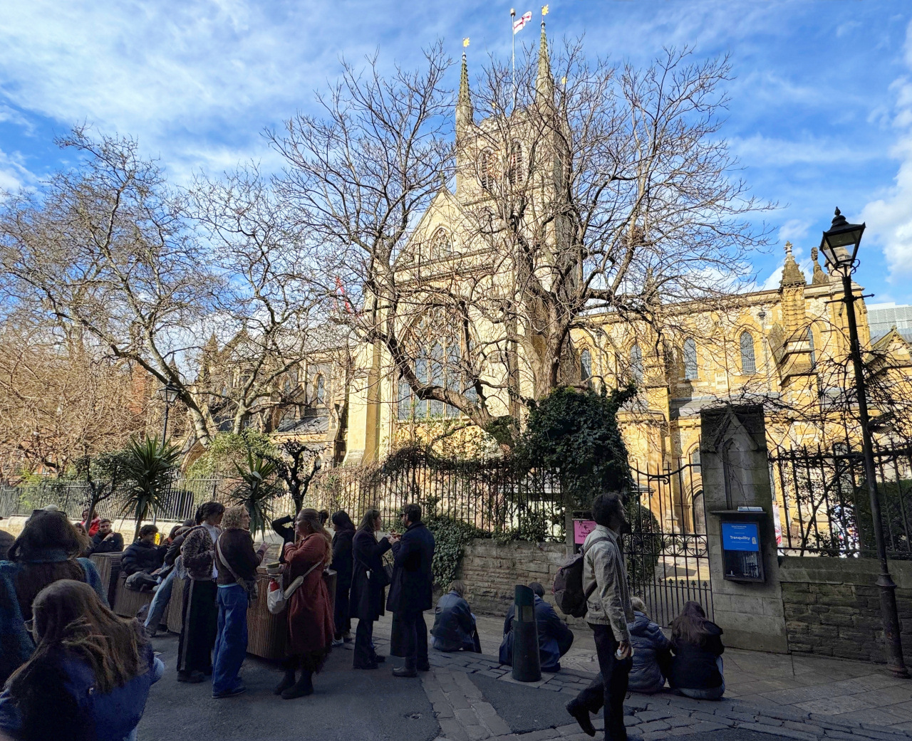

If you have time to visit the cathedral then, unlike many, there is no admission charge (though a £5 donation would be gratefully received).
Southwark Cathedral stands at the oldest crossing point of the tidal River Thames into what became the City of London. There has been a religious community here for over 1,400 years, beginning in the 7th century when it is believed a community of nuns lived here. Swithun, who became the Bishop of Winchester in the 9th century, later replaced the nuns with priests. The first written reference to the church – as a ‘minster’ – is in the 1086 Domesday Book. Around 1212 a new church was built – the first Gothic church to be built in London.
It is worth adding that it only became a cathedral in 1905. Today it serves a large diocese that stretches as far south as Gatwick Airport, with a population of two and a half million.
The Cathedral has many links to well-known people from the past, including:
- John Gower, the poet, has a tomb here. He was a friend of Geoffrey Chaucer, whose Canterbury Tales began in Southwark.

- William Shakespeare’s brother Edmund is buried here (and a stained-glass window depicts scenes from Shakespeare’s plays).
- Bishop Lancelot Andrews, who translated the first five books of the Authorised Version of the Bible into English, is buried beside the High Altar.
- John Harvard, founder of Harvard University, was born in Southwark and baptised here.
- Nelson Mandela opened the new cloister here in 2001. It has a library, refectory and education centre.
- There is also a modern memorial for the 51 people who died when the Marchioness pleasure boat sank close by in 1989 after being struck by a dredger.
You can read more about the cathedral’s history here.
Next we visit Borough Market, so from the cathedral retrace your steps and follow the road around into Cathedral Street. After 50 yards or so, turn right into Winchester Walk – ignore the two openings on the left, continue to the end then turn left into Stoney Street.
Carry on up Stoney Street until you reach the Market Porter pub on the corner of Park Street, then turn left into the glass-covered market, the site of the original market, which has massively expanded over the years.
The first mention of a market in Southwark appears to be during a Scandinavian invasion in the 11th century. However, it wasn’t until1756 that records showed it being in the permanent place it is today.
During the 1970s the market had declined, but today its popularity is quite staggering! In recent years it has outgrown its original space, as the number of stalls has now expanded so much and these have been joined by many restaurants and bars in the surrounding streets.
The market is run for the benefit of its customers and general community by a charity with board of volunteer trustees taking care of day-to-day activities, which I suggest has kept its originality and popularity.


Immediately you enter the market one of my favourite stalls is on the right: it’s Le Marché du Quartier, with enormous displays of fresh, tinned and bottled French delicacies.
Just a few yards ahead where at a weekends or popular holiday periods you are likely to see a line of people queuing – they’ll be waiting to buy the paellas (and much else) from the Furness seafood and fish stall. There’s always so much laid out (and so attractively) so I asked one day about the wastage, as of course seafood and fish must have the shortest shelf life of any foods. The staff pointed to the huge paella cooking pans and said nothing is ever wasted – if it’s still fresh and hasn’t been sold it all goes into their famous paellas – the reason for the queue! The stall has been featured in Jamie Oliver’s book Jamie’s Kitchen, where they are referred to as ‘the heroes of Borough Market’.

I suggest you keep walking straight ahead and cross the road into the Green Market.
(And I’m sure you’ve already realised, but the noise you can hear is not thunder, but the trains above on the old iron viaducts!)
Whilst it’s easy to get diverted by the many attractive stalls, I suggest that you keep walking straight ahead, with the cathedral’s garden on the left and into the narrow Green Dragon Court (though you may not see the sign), squeeze past the Whiskey Ginger stall and go up the steps.
At the top you get a lovely view of the east side of the cathedral beneath you.
You have now arrived at London Bridge.
The Romans built the first Thames crossing between Southwark and what today is the City of London.
Back then, the river was much wider than it is today as there were no manmade banks. This meant that at high tide much of the land surrounding the river would have regularly flooded. So, the place the Romans chose on each bank was the firmest and so the best place for a bridge. That bridge was likely to have been a form of wooden pontoon and constructed using wooden planks laid across anchored boats.
The Romans abandoned London around 409 AD, and it wasn’t occupied again for nearly six hundred years when the Saxons arrived around the year 1000. The Romans’ wooden bridge didn’t last, so the Saxons built a new one but again made out of timber. That was destroyed by a storm and whilst there were attempts to build new wooden bridges, it wasn’t until 1209 that the first stone bridge was erected. Later known as Old London Bridge, it had fortified gates, a drawbridge and towers. It was the longest inhabited bridge in Europe, a wonder of the medieval world, and there were so many houses, businesses and inns on the bridge you might have thought you were on any other busy London street.
You can read more about London Bridge in the appendix.

At the top of the steps turn left and walk past the Barrow Boy and Banker pub and at Bridge House cross over the busy road. The walk continues directly ahead into Tooley Street and not over London Bridge, but if you want to have a closer look at the river views then walk to the left and when you’re done, turn back and left into Duke Street Hill – it becomes Tooley Street after a couple of hundred yards.
Once you’re across, look over to the right to see the unusual semi-curved shop built into the supports of the viaduct carrying the railway across Borough High Street that still has the name Findlater above it. Findlaters – their full name was Findlater, Mackie and Todd – had opened here in 1865. They were specialist wine importers, famous for being the wine merchants to the royal family.

Head down Duke Street Hill that runs parallel with the railway viaduct. After a few hundred yards it joins Tooley Street. On the left is the six-storey St Olaf House, a Grade II listed building clad in Portland stone that was built on the site of St Olave’s Church and opened in 1931. It has a particularly attractive art deco design, known for its intricate panels on the riverside featuring terracotta panels designed by Frank Dobson that represent Industry, Capital and Labour. Today it is part of the private London Bridge Hospital, which was originally called ‘Emblem House’.

A plaque says “On the ground occupied by this building stood formerly the church of St Olave. This church was founded in the eleventh century in memory of St Olaf or Olave – King of Norway, who in the year 1014 helped King Ethelred defend the City of London against the Danes. The original building survived until 1734 and was then rebuilt to the designs of Henry Flitcroft. It was damaged by fire in 1843 and rebuilt afterwards to the same design. It was demolished in 1928, the proceeds of the sale of that portion of the site vested in the Bermondsey Borough Council have been applied to the establishment of a recreation ground in Tanner Street SE1.”
Next to St Olaf House are the main buildings of the London Bridge Hospital. Next to that is the Cotton Centre, The Cotton Centre was constructed in the 1980s on the site of the former Hay’s Wharf. It’s a complex of offices, flats and shops in two nine-storey units that are linked by a glass atrium. Part of this enormous redevelopment included the Hay’s Galleria, which we visit next.
Opposite Emblem House (London Bridge Hospital) is one of the entrances to the London Bridge mainline & Underground station. However, the new main entrance is a little further down. The station has undergone massive re-engineering and refurbishment costing around one billion pounds. It’s the terminus for several main line train services and is Britain’s fourth busiest station. It also connects with the Northern and Jubilee line stations. It’s one of the world’s oldest – built in the 1830s. Originally it served the London and Greenwich Railway that linked with the steamers that departed from Greenwich.
Opposite the station entrance turn left into the passage that leads into the Hay’s Galleria.
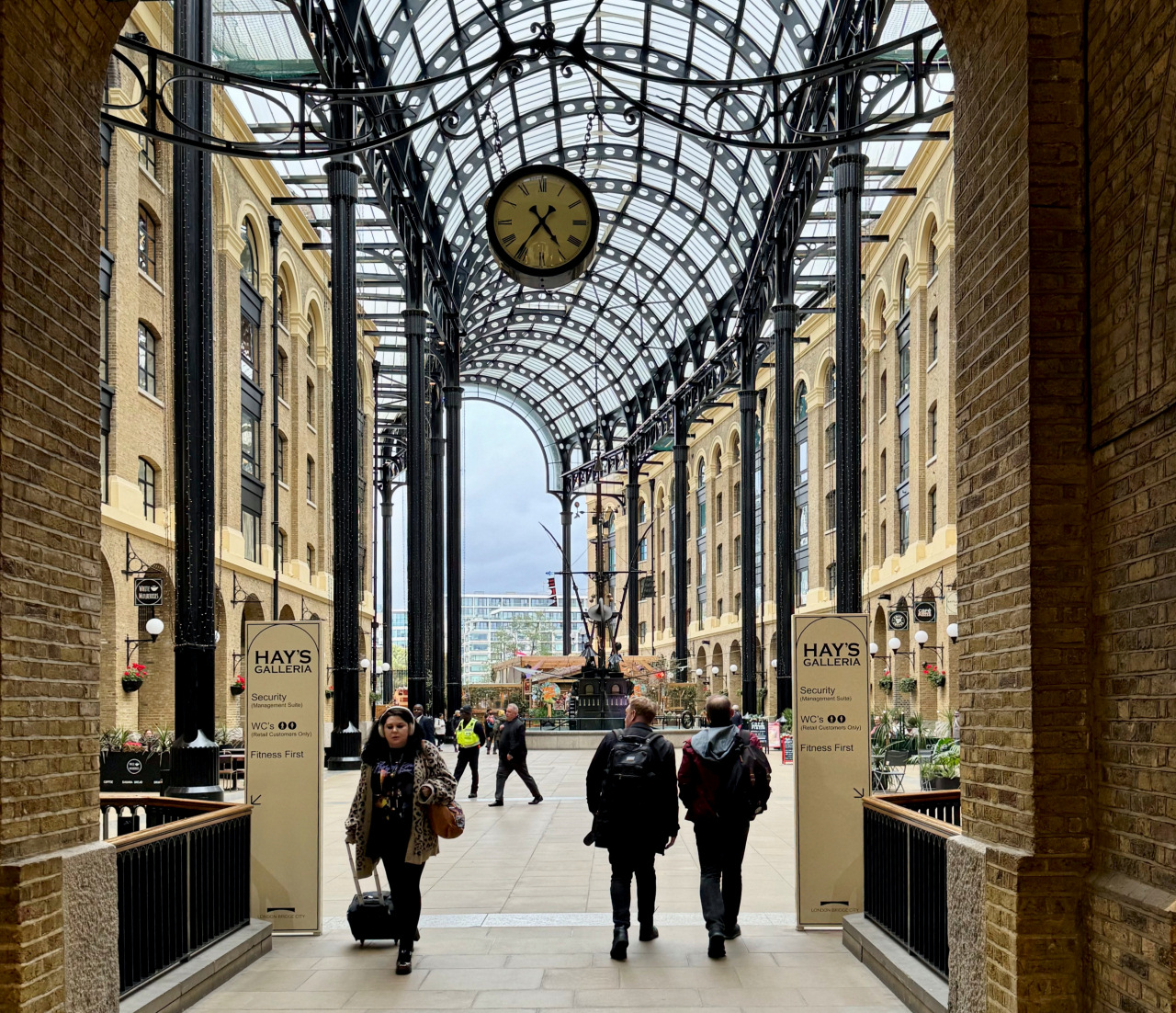
This was once a 17th century brewery that was named after its founder, Alexander Hay. It was later turned into an ‘import dock’ where products, particularly tea, were unloaded. It had a dock that was fitted with lock gates, so that ships could sail in at high tide and with the gates closed behind them wouldn’t be affected as the tide drew out. Once unloaded, the ships would wait until the next high tide and be able to sail back out.
Having been badly damaged in the Second World War but later rebuilt, it finally closed and for many years had become disused and virtually derelict.
It was redeveloped in the 1980s and apparently intended to be a ‘posh’ shopping centre, along the lines of the Galleria in Milan’s Piazza del Duomo. Whilst I don’t think it has ever really caught on, I do remember it having more attractive shops and being much busier in the 1990s. At one time there was also an ‘indoor market’, and whilst some stalls and barrows seem to have been reinstated, it no longer seems as popular as it once was.
One of the ‘highlights’ is the unusual 60-foot bronze sculpture in what would have been a part of the dock. It’s called the ‘Navigators’ by the sculptor David Kemp and has the body of a ship, with moving oars, and the face of a man.

The Galleria opens onto the river path – as you turn right you pass a pub called The Horniman At Hay’s – a rather tenuous connection with tea. Frederic Horniman was a famous importer of tea and friezes within the pub depict his travels to India, Africa and the Americas. And in case you’ve never heard of Horniman’s Tea, today the brand is more popular in Spain and Uruguay than in Britain.
I will just mention that there is a Horniman’s museum that along with much else does have an exhibit that features tea. You’ll find it in Forest Hill, in south London.
On the other side of the river, you can see the Custom House. Whilst this neo-classical building was only built 200 years ago, it’s on the site of previous ‘customs houses’ where duties have been paid on cargoes being brought into the city since 1275. The building has been empty since 2021, but plans are afoot for it to become a (rather posh!) 170-bed hotel.
Customs duties were originally levied on goods leaving the country. Back in medieval times England was exporting enormous quantities of sheep’s wool. A ‘customs levy’ was imposed on these exports that were paid to the government.
If you’d like to know more about the Custom House, take a look at this article.


Once you pass Hay’s Galleria the view is dominated by the naval cruiser, HMS Belfast. Built in Belfast by the Harland & Wolff shipyard (who also built the Titanic), it was launched in 1938 and had nine decks and a crew of nearly 2,000.
The ship saw active service during the Second World War, taking part in protecting the Artic convoys, the sinking of the German battlecruiser ‘Scharnhorst’ and the Normandy landings. Before becoming a floating museum, it was used by the United Nations for service in the Korean War.
It’s been moored here as a floating museum since 1971. It’s certainly a large exhibit to explore – the curators recommend a minimum of three hours to properly visit the ship.
After the Belfast the view ahead is dominated by the magnificent Tower Bridge. Across on the north bank is the far older Tower of London (which I’ve written about in the appendix). Whilst coming up next you can see what used to be London’s City Hall.
I suggest you walk up the steps on the right to the raised promenade that’s in front of the Tavolino Italian restaurant. I can thoroughly recommend the restaurant, having eaten there several times. Bearing in mind its position, view and excellent food and service, it is surprisingly reasonably priced, (at least for London!)
Unmissable in front of you is the enormous bulbous-shaped City Hall. Or rather was, as I will explain next.
In front of it is what’s known as the Scoop. It’s a sunken amphitheatre seating up to a thousand people and used mainly in the summer for events such music, theatre and films, many of which are free.
City Hall was the headquarters of the Greater London Authority and this iconic building was its headquarters. However, when Sadiq Khan replaced Boris Johnson as Mayor of London, he decided to move the centre of London’s administration to a new headquarters further down the river in east London.
When Boris Johnson was mayor, he was said to have had a number of nicknames for the building. One was apparently a ‘Glass Testicle’ or ‘Glass Gonad’. Other names included The Onion, Darth Vader’s Helmet or the Woodlouse.

Tower Bridge, which opened in 1894, is one of the world’s most iconic bridges and an image that’s recognised across the world.
Not only is its design so spectacular, but it’s a monument to the ingenuity of Victorian engineering. And its neo-Gothic architectural style is said to have been chosen by Queen Victoria to blend in with the adjacent Tower of London.
It was a great success, allowing both road and foot traffic across the River Thames, whilst still giving access to tall ships sailing to the wharves in the Pool of London. In its first year the bascules were raised over six thousand times. Today, they still rise around eight hundred times a year.
Having played a key role in London celebrations including the Diamond Jubilee Pageant and the London Olympics in 2012, Tower Bridge remains an important piece of London culture and is undeniably one of London’s most iconic structures.
Visit the original steam engines – and cross the glass floor of the bridge.
Originally the bridge’s bascules were operated by steam power (you can still see the original pumping engines in the Engine Rooms). Whilst still operated by hydraulic power, this is driven by oil and electricity.
Another more recent attraction is the glass floor of the high-level walkway between the towers. The original floor was ‘replaced’ with glass panels in 2014, and you can now have the scary option of crossing the bridge whilst having a great view of the river and road below. No good I’m sure for those with vertigo!
Today the bridge is still bound by the Tower Bridge Act, which was passed by an Act of Parliament in 1885, which gives river traffic priority over road traffic, regardless of how long the traffic jams are! The Act also states that the bridge is to be opened free of charge for river traffic.
And for those who like statistics …
- The tidal rise and fall of the Thames at this point is 23 feet.
- 40,000 pedestrians, cycles and vehicles cross the bridge every day.
- Each bascule weights 1,200 tons.
- The crests on top of the towers are almost 206 feet above road level and are gilded with gold.
- The length of central span between the towers is almost 206 feet.
- The foundations into the riverbed are at a depth of almost 26 feet.
- Around 31 million bricks and two million rivets were used in the construction of the bridge.
- The highest-ever number of bridge lifts in one day was 64.
- By law, a bundle of hay must be suspended from Tower Bridge when work is happening. This is to alert ships that there is less room to pass under its bascules than normal.
|
Finish: Tower Bridge |
Congratulations if you’ve now reached the end of the walk!
But before you make a final decision as to what to do next, may I offer three options.
- To end the walk now, I suggest you climb the steps up on to the bridge – if you turn right and walk back along Tower Bridge Road there’s a stop for buses to take you across the bridge to the north bank and back into the city. ALTERNATIVELY, if you walk across, you’ll find Tower Hill tube station on the Circle and District lines just a few minutes’ walk further on. In addition, there’s also the Tower Gateway DLR station for destinations to the east.
- For London Bridge station, with both National Rail services and the Northern line, turn around and walk back, passing City Hall on your right and walk along Tooley Street.
- However, my preferred suggestion – before you head back – is to walk on through the underpass beneath Tower Bridge into Shad Thames.

SHAD THAMES
As soon as you enter Shad Thames, you can see that it’s an iconic historic street. So much so that it’s been used in many films over the years, including Alfie in 1966 and two years later in Oliver.
Goods that had arrived here by ship were transferred from the quayside into the warehouses on both sides of the road. Some would have been wheeled on barrows or carried across by porters, but some would have been taken along the ‘metal walkways’ above the street.
These warehouses were built in 1874 and survived the intensive bombing of the Second World War. These days many have been turned into apartments, with upmarket restaurants and tourist shops on their ground floors. I suggest you walk through one of the alleyways to the riverside where you can see several of the quayside restaurants, including Le Pont de la Tour.
You can walk on further along the quayside to where Terence Conran converted a banana warehouse to become his famous Design Museum in 1989. (It’s now in Kensington.)
When you’ve seen enough, walk back to the bridge to finish your walk – or enjoy a meal in one of the delightful restaurants on the water’s edge in Shad Thames.